 Warner Robins
Wantagh
Bethel
Misty Hill Farm
United States
Wakonda Beach (R33) Airport
Wilmington
Poland
Miami International Airport
Warner Robins
Wantagh
Bethel
Misty Hill Farm
United States
Wakonda Beach (R33) Airport
Wilmington
Poland
Miami International Airport
Mississippi Gateway Regional Park on the map, Brooklyn Park, United States
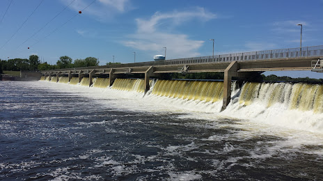
Photo
Where is located Mississippi Gateway Regional Park
Mississippi Gateway Regional Park — local attraction, which is located at 10360 W River Rd, Brooklyn Park, MN 55444, United States and belongs to the category — park. Average visitor rating for this place — 4.7 (according to 1096 ratings, information from open sources and relevant for 2022).
Exact location — Mississippi Gateway Regional Park, marked on the map with a red marker.
You can get directions to Mississippi Gateway Regional Park on the map from your location.
What else is interesting in Brooklyn Park? You can see all the sights if you go to the city page.
Coordinates
Mississippi Gateway Regional Park, United States coordinates in decimal format: latitude — 45.141271040590595, longitude — -93.31467377499851. When converted to degrees, minutes, seconds Mississippi Gateway Regional Park has the following coordinates: 45°8′28.58 north latitude and -93°18′52.83 east longitude.
Nearby cities
The largest cities that are located nearby:
- Minneapolis — 15 km
- Saint Paul — 26 km
- Sioux Falls — 320 km
- Des Moines — 387 km
- Madison — 390 km
- Green Bay — 425 km
- Rockford — 468 km
- Omaha — 478 km
- Milwaukee — 496 km
- Lincoln — 548 km
- Aurora — 555 km
- Naperville — 566 km
- Peoria — 580 km
- Joliet — 589 km
- Chicago — 590 km
- Winnipeg
 (Canada) — 596 km
 - Grand Rapids — 665 km
- North Kansas City — 666 km
- Independence — 670 km
Distance to the capital
Distance to the capital (Washington) is about — 1509 km.