
 Bel-Ha
San Jose El Alto
El Porvenir
Nueva Palestina
Santa Lucía
Chemax
La Morita
Temoac
Zacualpan
Bel-Ha
San Jose El Alto
El Porvenir
Nueva Palestina
Santa Lucía
Chemax
La Morita
Temoac
Zacualpan
Parque Bicentenario on the map, Santa Rosa Jáuregui, Mexico
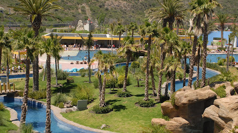
Photo
Where is located Parque Bicentenario
Parque Bicentenario — local attraction, which is located at Calle Melchor Ocampo Poniente 3-C, 76220 Santa Rosa Jáuregui, Qro., Mexico and belongs to the category — amusement park. Average visitor rating for this place — 4.4 (according to 13308 ratings, information from open sources and relevant for 2022).
Exact location — Parque Bicentenario, marked on the map with a red marker.
You can get directions to Parque Bicentenario on the map from your location.
What else is interesting in Santa Rosa Jáuregui? You can see all the sights if you go to the city page.
Coordinates
Parque Bicentenario, Mexico coordinates in decimal format: latitude — 20.738169617680775, longitude — -100.44803122561737. When converted to degrees, minutes, seconds Parque Bicentenario has the following coordinates: 20°44′17.41 north latitude and -100°26′52.91 east longitude.
Nearby cities
The largest cities that are located nearby:
- Santiago de Querétaro — 18 km
- Celaya — 45 km
- San Juan del Río — 62 km
- Salamanca — 80 km
- Irapuato — 94 km
- León — 135 km
- Morelia — 139 km
- San Luis Potosi — 166 km
- Soledad de Graciano Sánchez — 167 km
- Cuautitlán Izcalli — 174 km
- Ciudad López Mateos — 180 km
- Toluca — 181 km
- Buenavista — 183 km
- Coacalco — 186 km
- Metepec — 187 km
- Tlalnepantla — 187 km
- Naucalpan — 188 km
- Ojo de Agua — 189 km
- Pachuca — 189 km
Distance to the capital
Distance to the capital (Mexico City) is about — 200 km.