 Warner Robins
Wantagh
Bethel
Misty Hill Farm
United States
Wakonda Beach (R33) Airport
Wilmington
Poland
Miami International Airport
Warner Robins
Wantagh
Bethel
Misty Hill Farm
United States
Wakonda Beach (R33) Airport
Wilmington
Poland
Miami International Airport
Inlet Island on the map, Bonney Lake, United States
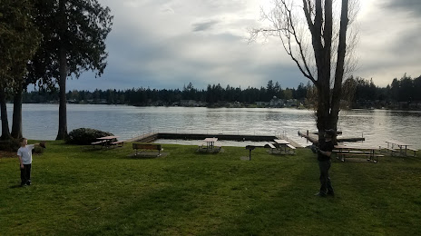
Photo
Where is located Inlet Island
Inlet Island — local attraction, which is located at 20198-20100 60th St E, Bonney Lake, WA 98391, United States and belongs to the category — historical landmark. Average visitor rating for this place — 4.6 (according to 24 ratings, information from open sources and relevant for 2022).
Exact location — Inlet Island, marked on the map with a red marker.
You can get directions to Inlet Island on the map from your location.
What else is interesting in Bonney Lake? You can see all the sights if you go to the city page.
Coordinates
Inlet Island, United States coordinates in decimal format: latitude — 47.20255883285923, longitude — -122.15492747492864. When converted to degrees, minutes, seconds Inlet Island has the following coordinates: 47°12′9.21 north latitude and -122°9′17.74 east longitude.
Nearby cities
The largest cities that are located nearby:
- Tacoma — 21 km
- Bellevue — 48 km
- Seattle — 49 km
- Victoria
 (Canada) — 163 km
 - Vancouver — 174 km
- Portland — 187 km
- Abbotsford (Canada) — 208 km
- Delta (Canada) — 221 km
- Surrey (Canada) — 227 km
- Richmond (Canada) — 230 km
- Coquitlam (Canada) — 237 km
- Burnaby (Canada) — 238 km
- Anmore (Canada) — 241 km
- Salem — 256 km
- Eugene — 353 km
- Kelowna (Canada) — 356 km
- Spokane — 359 km
- Boise — 619 km
- Calgary (Canada) — 708 km
Distance to the capital
Distance to the capital (Washington) is about — 3726 km.