 Warner Robins
Wantagh
Bethel
Misty Hill Farm
United States
Wakonda Beach (R33) Airport
Wilmington
Poland
Miami International Airport
Warner Robins
Wantagh
Bethel
Misty Hill Farm
United States
Wakonda Beach (R33) Airport
Wilmington
Poland
Miami International Airport
Vander Veer Botanical Park on the map, Davenport, United States
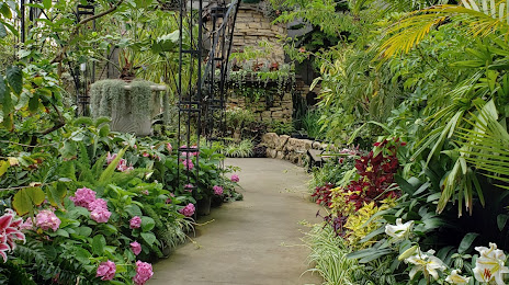
Photo
Where is located Vander Veer Botanical Park
Vander Veer Botanical Park — local attraction, which is located at 215 W Central Park Ave, Davenport, IA 52803, United States and belongs to the category — botanical garden. Average visitor rating for this place — 4.7 (according to 1963 ratings, information from open sources and relevant for 2022).
Exact location — Vander Veer Botanical Park, marked on the map with a red marker.
You can get directions to Vander Veer Botanical Park on the map from your location.
What else is interesting in Davenport? You can see all the sights if you go to the city page.
Coordinates
Vander Veer Botanical Park, United States coordinates in decimal format: latitude — 41.54416162955695, longitude — -90.5749101751145. When converted to degrees, minutes, seconds Vander Veer Botanical Park has the following coordinates: 41°32′38.98 north latitude and -90°34′29.68 east longitude.
Nearby cities
The largest cities that are located nearby:
- Peoria — 124 km
- Rockford — 147 km
- Aurora — 188 km
- Madison — 196 km
- Naperville — 202 km
- Joliet — 207 km
- Chicago — 246 km
- Des Moines — 251 km
- Milwaukee — 273 km
- Saint Louis — 322 km
- South Bend — 358 km
- Green Bay — 388 km
- Indianapolis — 423 km
- Independence — 425 km
- Saint Paul — 427 km
- Grand Rapids — 428 km
- North Kansas City — 432 km
- Kansas City — 436 km
- Minneapolis — 436 km
Distance to the capital
Distance to the capital (Washington) is about — 1185 km.