 Warner Robins
Wantagh
Bethel
Misty Hill Farm
United States
Wakonda Beach (R33) Airport
Wilmington
Poland
Miami International Airport
Warner Robins
Wantagh
Bethel
Misty Hill Farm
United States
Wakonda Beach (R33) Airport
Wilmington
Poland
Miami International Airport
Johns Hopkins Archaeological Museum on the map, Baltimore, United States
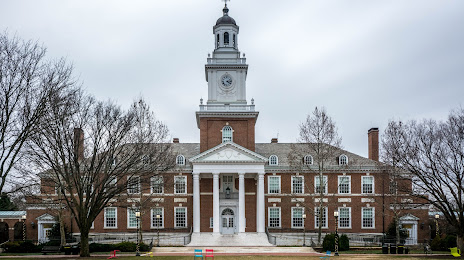
Photo
Where is located Johns Hopkins Archaeological Museum
Johns Hopkins Archaeological Museum — local attraction, which is located at 3400 N Charles St, Baltimore, MD 21218, United States and belongs to the category — archaeological museum. Average visitor rating for this place — 4.7 (according to 9 ratings, information from open sources and relevant for 2022).
Exact location — Johns Hopkins Archaeological Museum, marked on the map with a red marker.
You can get directions to Johns Hopkins Archaeological Museum on the map from your location.
What else is interesting in Baltimore? You can see all the sights if you go to the city page.
Coordinates
Johns Hopkins Archaeological Museum, United States coordinates in decimal format: latitude — 39.328922134136675, longitude — -76.62155827508742. When converted to degrees, minutes, seconds Johns Hopkins Archaeological Museum has the following coordinates: 39°19′44.12 north latitude and -76°37′17.61 east longitude.
Nearby cities
The largest cities that are located nearby:
- Alexandria — 65 km
- Philadelphia — 143 km
- Allentown — 174 km
- Richmond — 206 km
- Toms River — 217 km
- Edison — 229 km
- Hampton — 251 km
- Elizabeth — 252 km
- Newark — 259 km
- Brooklyn — 269 km
- New York — 269 km
- Norfolk — 271 km
- Paterson — 272 km
- Virginia Beach — 275 km
- Chesapeake — 280 km
- Yonkers — 290 km
- Pittsburgh — 312 km
- Stamford — 322 km
- Bridgeport — 353 km
Distance to the capital
Distance to the capital (Washington) is about — 59 km.