 Warner Robins
Wantagh
Bethel
Misty Hill Farm
United States
Wakonda Beach (R33) Airport
Wilmington
Poland
Miami International Airport
Warner Robins
Wantagh
Bethel
Misty Hill Farm
United States
Wakonda Beach (R33) Airport
Wilmington
Poland
Miami International Airport
Hawk Woods Park and Campground on the map, Auburn Hills, United States
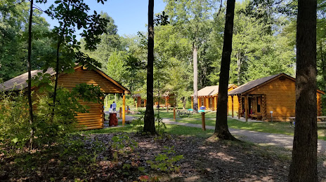
Photo
Where is located Hawk Woods Park and Campground
Hawk Woods Park and Campground — local attraction, which is located at 3799 Bald Mountain Rd, Auburn Hills, MI 48326, United States and belongs to the category — nature preserve. Average visitor rating for this place — 4.6 (according to 234 ratings, information from open sources and relevant for 2022).
Exact location — Hawk Woods Park and Campground, marked on the map with a red marker.
You can get directions to Hawk Woods Park and Campground on the map from your location.
What else is interesting in Auburn Hills? You can see all the sights if you go to the city page.
Coordinates
Hawk Woods Park and Campground, United States coordinates in decimal format: latitude — 42.69937859731936, longitude — -83.2341942749835. When converted to degrees, minutes, seconds Hawk Woods Park and Campground has the following coordinates: 42°41′57.76 north latitude and -83°14′3.1 east longitude.
Nearby cities
The largest cities that are located nearby:
- Sterling Heights — 20 km
- Warren — 26 km
- Detroit — 42 km
- Windsor
 (Canada) — 44 km
 - Flint — 51 km
- Ann Arbor — 61 km
- Lansing — 107 km
- Toledo — 116 km
- London (Canada) — 164 km
- Cleveland — 183 km
- Grand Rapids — 199 km
- Aurora — 218 km
- Akron — 228 km
- Waterloo (Canada) — 234 km
- Kitchener (Canada) — 236 km
- Fort Wayne — 238 km
- Cambridge (Canada) — 246 km
- Guelph (Canada) — 257 km
- South Bend — 273 km
Distance to the capital
Distance to the capital (Washington) is about — 671 km.