 Warner Robins
Wantagh
Bethel
Misty Hill Farm
United States
Wakonda Beach (R33) Airport
Wilmington
Poland
Miami International Airport
Warner Robins
Wantagh
Bethel
Misty Hill Farm
United States
Wakonda Beach (R33) Airport
Wilmington
Poland
Miami International Airport
Dismal Swamp State Park on the map, Chesapeake, United States
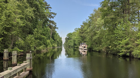
Photo
Where is located Dismal Swamp State Park
Dismal Swamp State Park — local attraction, which is located at 2294 US-17, South Mills, NC 27976, United States and belongs to the category — state park. Average visitor rating for this place — 4.6 (according to 577 ratings, information from open sources and relevant for 2022).
Exact location — Dismal Swamp State Park, marked on the map with a red marker.
You can get directions to Dismal Swamp State Park on the map from your location.
What else is interesting in Chesapeake? You can see all the sights if you go to the city page.
Coordinates
Dismal Swamp State Park, United States coordinates in decimal format: latitude — 36.522452224966685, longitude — -76.41905459888648. When converted to degrees, minutes, seconds Dismal Swamp State Park has the following coordinates: 36°31′20.83 north latitude and -76°25′8.6 east longitude.
Nearby cities
The largest cities that are located nearby:
- Norfolk — 9 km
- Virginia Beach — 29 km
- Hampton — 29 km
- Richmond — 132 km
- Alexandria — 234 km
- Raleigh — 237 km
- Cary — 248 km
- Durham — 249 km
- Baltimore — 280 km
- Fayetteville — 302 km
- Greensboro — 322 km
- Winston-Salem — 361 km
- Philadelphia — 365 km
- Toms River — 394 km
- Allentown — 430 km
- Edison — 444 km
- Charlotte — 445 km
- Elizabeth — 465 km
- Newark — 473 km
Distance to the capital
Distance to the capital (Washington) is about — 271 km.