 Warner Robins
Wantagh
Bethel
Misty Hill Farm
United States
Wakonda Beach (R33) Airport
Wilmington
Poland
Miami International Airport
Warner Robins
Wantagh
Bethel
Misty Hill Farm
United States
Wakonda Beach (R33) Airport
Wilmington
Poland
Miami International Airport
Arthur's Rock on the map, Fort Collins, United States
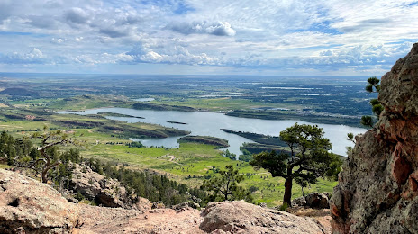
Photo
Where is located Arthur's Rock
Arthur's Rock — local attraction, which is located at Fort Collins, CO 80526, United States and belongs to the category — hiking area. Average visitor rating for this place — 5.0 (according to 6 ratings, information from open sources and relevant for 2022).
Exact location — Arthur's Rock, marked on the map with a red marker.
You can get directions to Arthur's Rock on the map from your location.
What else is interesting in Fort Collins? You can see all the sights if you go to the city page.
Coordinates
Arthur's Rock, United States coordinates in decimal format: latitude — 40.567969904361775, longitude — -105.18719747504998. When converted to degrees, minutes, seconds Arthur's Rock has the following coordinates: 40°34′4.69 north latitude and -105°11′13.91 east longitude.
Nearby cities
The largest cities that are located nearby:
- Thornton — 80 km
- Westminster — 83 km
- Arvada — 87 km
- Denver — 94 km
- Aurora — 97 km
- Lakewood — 97 km
- Colorado Springs — 195 km
- Pueblo — 261 km
- Provo — 556 km
- Salt Lake City — 570 km
- West Jordan — 575 km
- West Valley City — 580 km
- Albuquerque — 623 km
- Valencia — 656 km
- Amarillo — 662 km
- Lincoln — 703 km
- Sioux Falls — 745 km
- Wichita — 750 km
- Omaha — 759 km
Distance to the capital
Distance to the capital (Washington) is about — 2405 km.