 Warner Robins
Wantagh
Bethel
Misty Hill Farm
United States
Wakonda Beach (R33) Airport
Wilmington
Poland
Miami International Airport
Warner Robins
Wantagh
Bethel
Misty Hill Farm
United States
Wakonda Beach (R33) Airport
Wilmington
Poland
Miami International Airport
Northwoods Trails on the map, Hot Springs, United States
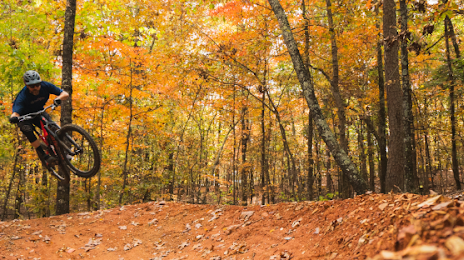
Photo
Where is located Northwoods Trails
Northwoods Trails — local attraction, which is located at 300 Pineland Dr, Hot Springs, AR 71901, United States and belongs to the category — park. Average visitor rating for this place — 5.0 (according to 5 ratings, information from open sources and relevant for 2022).
Exact location — Northwoods Trails, marked on the map with a red marker.
You can get directions to Northwoods Trails on the map from your location.
What else is interesting in Hot Springs? You can see all the sights if you go to the city page.
Coordinates
Northwoods Trails, United States coordinates in decimal format: latitude — 34.538278410148685, longitude — -93.06115287522272. When converted to degrees, minutes, seconds Northwoods Trails has the following coordinates: 34°32′17.8 north latitude and -93°3′40.15 east longitude.
Nearby cities
The largest cities that are located nearby:
- Little Rock — 75 km
- Shreveport — 228 km
- Memphis — 281 km
- Springfield — 300 km
- Tulsa — 319 km
- Jackson — 362 km
- Plano — 376 km
- Garland — 376 km
- Frisco — 380 km
- Mesquite — 381 km
- Richardson — 382 km
- Carrollton — 394 km
- Dallas — 397 km
- Denton — 403 km
- Norman — 404 km
- Irving — 407 km
- Grand Prairie — 415 km
- Oklahoma City — 416 km
- Arlington — 425 km
Distance to the capital
Distance to the capital (Washington) is about — 1507 km.