 Warner Robins
Wantagh
Bethel
Misty Hill Farm
United States
Wakonda Beach (R33) Airport
Wilmington
Poland
Miami International Airport
Warner Robins
Wantagh
Bethel
Misty Hill Farm
United States
Wakonda Beach (R33) Airport
Wilmington
Poland
Miami International Airport
Black Hill Regional Park on the map, Gaithersburg, United States
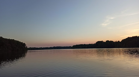
Photo
Where is located Black Hill Regional Park
Black Hill Regional Park — local attraction, which is located at 20930 Lake Ridge Dr, Boyds, MD 20841, United States and belongs to the category — park. Average visitor rating for this place — 4.8 (according to 1137 ratings, information from open sources and relevant for 2022).
Exact location — Black Hill Regional Park, marked on the map with a red marker.
You can get directions to Black Hill Regional Park on the map from your location.
What else is interesting in Gaithersburg? You can see all the sights if you go to the city page.
Coordinates
Black Hill Regional Park, United States coordinates in decimal format: latitude — 39.19276586154873, longitude — -77.29539507509145. When converted to degrees, minutes, seconds Black Hill Regional Park has the following coordinates: 39°11′33.96 north latitude and -77°17′43.42 east longitude.
Nearby cities
The largest cities that are located nearby:
- Alexandria — 40 km
- Baltimore — 53 km
- Richmond — 178 km
- Philadelphia — 194 km
- Allentown — 216 km
- Hampton — 246 km
- Norfolk — 266 km
- Toms River — 270 km
- Chesapeake — 275 km
- Virginia Beach — 275 km
- Pittsburgh — 275 km
- Edison — 279 km
- Elizabeth — 302 km
- Newark — 309 km
- Brooklyn — 319 km
- New York — 319 km
- Paterson — 320 km
- Yonkers — 339 km
- Stamford — 371 km
Distance to the capital
Distance to the capital (Washington) is about — 39 km.