 Warner Robins
Wantagh
Bethel
Misty Hill Farm
United States
Wakonda Beach (R33) Airport
Wilmington
Poland
Miami International Airport
Warner Robins
Wantagh
Bethel
Misty Hill Farm
United States
Wakonda Beach (R33) Airport
Wilmington
Poland
Miami International Airport
Cummins Falls on the map, Cookeville, United States
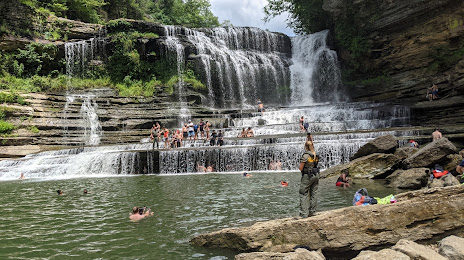
Photo
Where is located Cummins Falls
Cummins Falls — local attraction, which is located at 8981, 1081 Cummins Mill Rd, Cookeville, TN 38501, United States and belongs to the category — tourist attraction. Average visitor rating for this place — 4.8 (according to 398 ratings, information from open sources and relevant for 2022).
Exact location — Cummins Falls, marked on the map with a red marker.
You can get directions to Cummins Falls on the map from your location.
What else is interesting in Cookeville? You can see all the sights if you go to the city page.
Coordinates
Cummins Falls, United States coordinates in decimal format: latitude — 36.249190491957194, longitude — -85.57215882288293. When converted to degrees, minutes, seconds Cummins Falls has the following coordinates: 36°14′57.09 north latitude and -85°34′19.77 east longitude.
Nearby cities
The largest cities that are located nearby:
- Nashville — 114 km
- Chattanooga — 125 km
- Knoxville — 143 km
- Clarksville — 170 km
- Huntsville — 187 km
- Louisville — 232 km
- Evansville — 269 km
- Atlanta — 286 km
- Birmingham — 316 km
- Cincinnati — 336 km
- Indianapolis — 403 km
- Memphis — 426 km
- Montgomery — 426 km
- Charlotte — 433 km
- Springfield — 440 km
- Winston-Salem — 470 km
- Columbus — 470 km
- Columbia — 474 km
- Saint Louis — 489 km
Distance to the capital
Distance to the capital (Washington) is about — 808 km.