 Warner Robins
Wantagh
Bethel
Misty Hill Farm
United States
Wakonda Beach (R33) Airport
Wilmington
Poland
Miami International Airport
Warner Robins
Wantagh
Bethel
Misty Hill Farm
United States
Wakonda Beach (R33) Airport
Wilmington
Poland
Miami International Airport
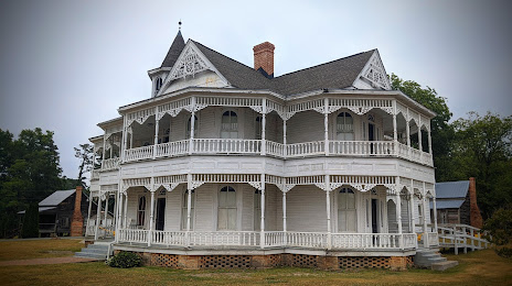
John Blue House and Heritage Center on the map, Laurinburg, United States
Photo
Where is located John Blue House and Heritage Center
John Blue House and Heritage Center — local attraction, which is located at 13040 X Way Rd, Laurinburg, NC 28352, United States and belongs to the category — historical landmark. Average visitor rating for this place — 4.5 (according to 82 ratings, information from open sources and relevant for 2022).
Exact location — John Blue House and Heritage Center, marked on the map with a red marker.
You can get directions to John Blue House and Heritage Center on the map from your location.
What else is interesting in Laurinburg? You can see all the sights if you go to the city page.
Coordinates
John Blue House and Heritage Center, United States coordinates in decimal format: latitude — 34.75732771503125, longitude — -79.4987291752168. When converted to degrees, minutes, seconds John Blue House and Heritage Center has the following coordinates: 34°45′26.38 north latitude and -79°29′55.43 east longitude.
Nearby cities
The largest cities that are located nearby:
- Fayetteville — 61 km
- Cary — 128 km
- Raleigh — 134 km
- Charlotte — 134 km
- Durham — 144 km
- Greensboro — 147 km
- Winston-Salem — 162 km
- Columbia — 168 km
- Charleston — 225 km
- Savannah — 335 km
- Richmond — 354 km
- Chesapeake — 357 km
- Norfolk — 363 km
- Hampton — 371 km
- Virginia Beach — 385 km
- Knoxville — 420 km
- Atlanta — 467 km
- Alexandria — 492 km
- Chattanooga — 530 km
Distance to the capital
Distance to the capital (Washington) is about — 511 km.