 Warner Robins
Wantagh
Bethel
Misty Hill Farm
United States
Wakonda Beach (R33) Airport
Wilmington
Poland
Miami International Airport
Warner Robins
Wantagh
Bethel
Misty Hill Farm
United States
Wakonda Beach (R33) Airport
Wilmington
Poland
Miami International Airport
Warriors' Path State Park on the map, Kingsport, United States
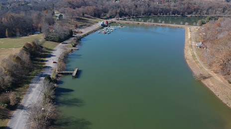
Photo
Where is located Warriors' Path State Park
Warriors' Path State Park — local attraction, which is located at 490 Hemlock Rd, Kingsport, TN 37663, United States and belongs to the category — state park. Average visitor rating for this place — 4.7 (according to 2649 ratings, information from open sources and relevant for 2022).
Exact location — Warriors' Path State Park, marked on the map with a red marker.
You can get directions to Warriors' Path State Park on the map from your location.
What else is interesting in Kingsport? You can see all the sights if you go to the city page.
Coordinates
Warriors' Path State Park, United States coordinates in decimal format: latitude — 36.497421468712034, longitude — -82.47942117516918. When converted to degrees, minutes, seconds Warriors' Path State Park has the following coordinates: 36°29′50.72 north latitude and -82°28′45.92 east longitude.
Nearby cities
The largest cities that are located nearby:
- Knoxville — 138 km
- Winston-Salem — 213 km
- Charlotte — 213 km
- Greensboro — 253 km
- Chattanooga — 299 km
- Columbia — 315 km
- Cincinnati — 328 km
- Durham — 333 km
- Louisville — 335 km
- Cary — 349 km
- Atlanta — 352 km
- Raleigh — 362 km
- Fayetteville — 372 km
- Nashville — 379 km
- Columbus — 379 km
- Springfield — 388 km
- Huntsville — 417 km
- Clarksville — 426 km
- Richmond — 463 km
Distance to the capital
Distance to the capital (Washington) is about — 549 km.