 Warner Robins
Wantagh
Bethel
Misty Hill Farm
United States
Wakonda Beach (R33) Airport
Wilmington
Poland
Miami International Airport
Warner Robins
Wantagh
Bethel
Misty Hill Farm
United States
Wakonda Beach (R33) Airport
Wilmington
Poland
Miami International Airport
Devil's Creek Brewery on the map, Cherry Hill, United States
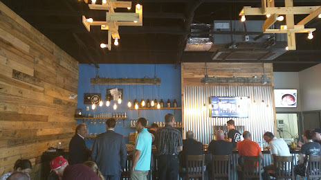
Photo
Where is located Devil's Creek Brewery
Devil's Creek Brewery — local attraction, which is located at 1 Powell Ln, Collingswood, NJ 08108, United States and belongs to the category — brewery. Average visitor rating for this place — 4.6 (according to 171 rating, information from open sources and relevant for 2022).
Exact location — Devil's Creek Brewery, marked on the map with a red marker.
You can get directions to Devil's Creek Brewery on the map from your location.
What else is interesting in Cherry Hill? You can see all the sights if you go to the city page.
Coordinates
Devil's Creek Brewery, United States coordinates in decimal format: latitude — 39.91687195000703, longitude — -75.07148407506978. When converted to degrees, minutes, seconds Devil's Creek Brewery has the following coordinates: 39°55′0.74 north latitude and -75°4′17.34 east longitude.
Nearby cities
The largest cities that are located nearby:
- Philadelphia — 12 km
- Toms River — 70 km
- Edison — 83 km
- Allentown — 85 km
- Elizabeth — 106 km
- Newark — 114 km
- Brooklyn — 121 km
- New York — 122 km
- Paterson — 131 km
- Yonkers — 146 km
- Baltimore — 153 km
- Stamford — 176 km
- Bridgeport — 206 km
- Alexandria — 214 km
- New Haven — 232 km
- Waterbury — 243 km
- Hartford — 280 km
- Springfield — 313 km
- Amherst — 337 km
Distance to the capital
Distance to the capital (Washington) is about — 203 km.