 Warner Robins
Wantagh
Bethel
Misty Hill Farm
United States
Wakonda Beach (R33) Airport
Wilmington
Poland
Miami International Airport
Warner Robins
Wantagh
Bethel
Misty Hill Farm
United States
Wakonda Beach (R33) Airport
Wilmington
Poland
Miami International Airport
Franklin County Historical Society on the map, Chambersburg, United States
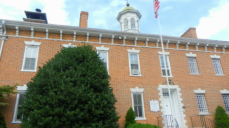
Photo
Where is located Franklin County Historical Society
Franklin County Historical Society — local attraction, which is located at 175 E King St, Chambersburg, PA 17201, United States and belongs to the category — museum. Average visitor rating for this place — 4.8 (according to 6 ratings, information from open sources and relevant for 2022).
Exact location — Franklin County Historical Society, marked on the map with a red marker.
You can get directions to Franklin County Historical Society on the map from your location.
What else is interesting in Chambersburg? You can see all the sights if you go to the city page.
Coordinates
Franklin County Historical Society, United States coordinates in decimal format: latitude — 39.93892506193114, longitude — -77.6591051750691. When converted to degrees, minutes, seconds Franklin County Historical Society has the following coordinates: 39°56′20.13 north latitude and -77°39′32.78 east longitude.
Nearby cities
The largest cities that are located nearby:
- Baltimore — 115 km
- Alexandria — 136 km
- Allentown — 197 km
- Pittsburgh — 204 km
- Philadelphia — 212 km
- Richmond — 266 km
- Edison — 281 km
- Toms River — 294 km
- Elizabeth — 300 km
- Newark — 305 km
- Boston — 310 km
- Paterson — 311 km
- New York — 318 km
- Brooklyn — 319 km
- Yonkers — 333 km
- Buffalo — 341 km
- Hampton — 342 km
- Aurora — 342 km
- Akron — 345 km
Distance to the capital
Distance to the capital (Washington) is about — 127 km.