 Warner Robins
Wantagh
Bethel
Misty Hill Farm
United States
Wakonda Beach (R33) Airport
Wilmington
Poland
Miami International Airport
Warner Robins
Wantagh
Bethel
Misty Hill Farm
United States
Wakonda Beach (R33) Airport
Wilmington
Poland
Miami International Airport
Shawnee Indian Mission State Historic Site on the map, Leawood, United States
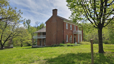
Photo
Where is located Shawnee Indian Mission State Historic Site
Shawnee Indian Mission State Historic Site — local attraction, which is located at 3403 W 53rd St, Fairway, KS 66205, United States and belongs to the category — historical place. Average visitor rating for this place — 4.4 (according to 128 ratings, information from open sources and relevant for 2022).
Exact location — Shawnee Indian Mission State Historic Site, marked on the map with a red marker.
You can get directions to Shawnee Indian Mission State Historic Site on the map from your location.
What else is interesting in Leawood? You can see all the sights if you go to the city page.
Coordinates
Shawnee Indian Mission State Historic Site, United States coordinates in decimal format: latitude — 39.03264947645822, longitude — -94.6247623750962. When converted to degrees, minutes, seconds Shawnee Indian Mission State Historic Site has the following coordinates: 39°1′57.54 north latitude and -94°37′29.14 east longitude.
Nearby cities
The largest cities that are located nearby:
- Overland Park — 5 km
- Kansas City — 15 km
- Olathe — 20 km
- North Kansas City — 20 km
- Independence — 22 km
- Topeka — 93 km
- Springfield — 227 km
- Lincoln — 269 km
- Wichita — 277 km
- Omaha — 278 km
- Des Moines — 303 km
- Tulsa — 334 km
- Saint Louis — 383 km
- Peoria — 463 km
- Oklahoma City — 467 km
- Norman — 486 km
- Little Rock — 512 km
- Sioux Falls — 534 km
- Rockford — 581 km
Distance to the capital
Distance to the capital (Washington) is about — 1519 km.