 Warner Robins
Wantagh
Bethel
Misty Hill Farm
United States
Wakonda Beach (R33) Airport
Wilmington
Poland
Miami International Airport
Warner Robins
Wantagh
Bethel
Misty Hill Farm
United States
Wakonda Beach (R33) Airport
Wilmington
Poland
Miami International Airport
Hogback Mountain on the map, Klamath Falls, United States
Photo
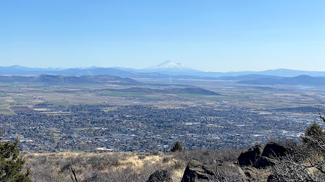
Where is located Hogback Mountain
Hogback Mountain — local attraction, which is located at 1,891 m and belongs to the category — -. Average visitor rating for this place — 4.8 (according to 6 ratings, information from open sources and relevant for 2022).
Exact location — Hogback Mountain, marked on the map with a red marker.
You can get directions to Hogback Mountain on the map from your location.
What else is interesting in Klamath Falls? You can see all the sights if you go to the city page.
Coordinates
Hogback Mountain, United States coordinates in decimal format: latitude — 42.242912886548275, longitude — -121.7066285114101. When converted to degrees, minutes, seconds Hogback Mountain has the following coordinates: 42°14′34.49 north latitude and -121°42′23.86 east longitude.
Nearby cities
The largest cities that are located nearby:
- Eugene — 227 km
- Salem — 316 km
- Reno — 342 km
- Portland — 371 km
- Vancouver — 384 km
- Roseville — 386 km
- Sacramento — 404 km
- Santa Rosa — 426 km
- Fairfield — 440 km
- Vallejo — 457 km
- Concord — 470 km
- Boise — 472 km
- Stockton — 474 km
- Richmond — 479 km
- Berkeley — 483 km
- Oakland — 491 km
- San Francisco — 495 km
- Hayward — 504 km
- Modesto — 512 km
Distance to the capital
Distance to the capital (Washington) is about — 3749 km.