 Warner Robins
Wantagh
Bethel
Misty Hill Farm
United States
Wakonda Beach (R33) Airport
Wilmington
Poland
Miami International Airport
Warner Robins
Wantagh
Bethel
Misty Hill Farm
United States
Wakonda Beach (R33) Airport
Wilmington
Poland
Miami International Airport
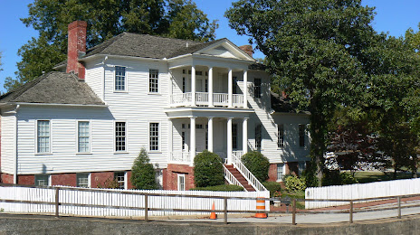
Dancy-Polk House on the map, Huntsville, United States
Photo
Where is located Dancy-Polk House
Dancy-Polk House — local attraction, which is located at 901 Railroad St NW, Decatur, AL 35601, United States and belongs to the category — building. Average visitor rating for this place — 4.7 (according to 7 ratings, information from open sources and relevant for 2022).
Exact location — Dancy-Polk House, marked on the map with a red marker.
You can get directions to Dancy-Polk House on the map from your location.
What else is interesting in Huntsville? You can see all the sights if you go to the city page.
Coordinates
Dancy-Polk House, United States coordinates in decimal format: latitude — 34.614799246721354, longitude — -86.98515937522062. When converted to degrees, minutes, seconds Dancy-Polk House has the following coordinates: 34°36′53.28 north latitude and -86°59′6.57 east longitude.
Nearby cities
The largest cities that are located nearby:
- Chattanooga — 121 km
- Birmingham — 135 km
- Nashville — 159 km
- Clarksville — 210 km
- Atlanta — 229 km
- Montgomery — 263 km
- Knoxville — 275 km
- Memphis — 316 km
- Evansville — 368 km
- Louisville — 396 km
- Jackson — 431 km
- Mobile — 467 km
- Cincinnati — 515 km
- Columbia — 515 km
- Little Rock — 518 km
- Charlotte — 522 km
- Tallahassee — 523 km
- Saint Louis — 532 km
- Indianapolis — 558 km
Distance to the capital
Distance to the capital (Washington) is about — 1006 km.