 Warner Robins
Wantagh
Bethel
Misty Hill Farm
United States
Wakonda Beach (R33) Airport
Wilmington
Poland
Miami International Airport
Warner Robins
Wantagh
Bethel
Misty Hill Farm
United States
Wakonda Beach (R33) Airport
Wilmington
Poland
Miami International Airport
E.E. Wilson Wildlife Area on the map, Corvallis, United States
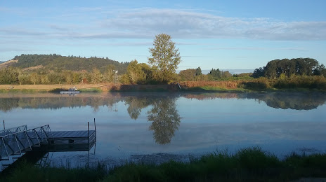
Photo
Where is located E.E. Wilson Wildlife Area
E.E. Wilson Wildlife Area — local attraction, which is located at 29555 Camp Adair Rd, Monmouth, OR 97361, United States and belongs to the category — hunting area. Average visitor rating for this place — 4.5 (according to 358 ratings, information from open sources and relevant for 2022).
Exact location — E.E. Wilson Wildlife Area, marked on the map with a red marker.
You can get directions to E.E. Wilson Wildlife Area on the map from your location.
What else is interesting in Corvallis? You can see all the sights if you go to the city page.
Coordinates
E.E. Wilson Wildlife Area, United States coordinates in decimal format: latitude — 44.700445662144645, longitude — -123.21145257491852. When converted to degrees, minutes, seconds E.E. Wilson Wildlife Area has the following coordinates: 44°42′1.6 north latitude and -123°12′41.23 east longitude.
Nearby cities
The largest cities that are located nearby:
- Salem — 45 km
- Eugene — 58 km
- Portland — 115 km
- Vancouver — 128 km
- Tacoma — 303 km
- Seattle — 343 km
- Bellevue — 346 km
- Victoria
 (Canada) — 427 km
 - Abbotsford (Canada) — 501 km
- Delta (Canada) — 501 km
- Richmond (Canada) — 509 km
- Surrey (Canada) — 512 km
- Burnaby (Canada) — 520 km
- Coquitlam (Canada) — 523 km
- Anmore (Canada) — 526 km
- Spokane — 553 km
- Boise — 574 km
- Reno — 630 km
- Kelowna (Canada) — 647 km
Distance to the capital
Distance to the capital (Washington) is about — 3830 km.