 Warner Robins
Wantagh
Bethel
Misty Hill Farm
United States
Wakonda Beach (R33) Airport
Wilmington
Poland
Miami International Airport
Warner Robins
Wantagh
Bethel
Misty Hill Farm
United States
Wakonda Beach (R33) Airport
Wilmington
Poland
Miami International Airport
End of the Oregon Trail Interpretive Center on the map, Oregon City, United States
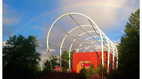
Photo
Where is located End of the Oregon Trail Interpretive Center
End of the Oregon Trail Interpretive Center — local attraction, which is located at 1726 Washington St, Oregon City, OR 97045, United States and belongs to the category — historical place museum. Average visitor rating for this place — 4.4 (according to 649 ratings, information from open sources and relevant for 2022).
Exact location — End of the Oregon Trail Interpretive Center, marked on the map with a red marker.
You can get directions to End of the Oregon Trail Interpretive Center on the map from your location.
What else is interesting in Oregon City? You can see all the sights if you go to the city page.
Coordinates
End of the Oregon Trail Interpretive Center, United States coordinates in decimal format: latitude — 45.365168658436374, longitude — -122.59443457489644. When converted to degrees, minutes, seconds End of the Oregon Trail Interpretive Center has the following coordinates: 45°21′54.61 north latitude and -122°35′39.96 east longitude.
Nearby cities
The largest cities that are located nearby:
- Portland — 19 km
- Vancouver — 31 km
- Salem — 57 km
- Eugene — 149 km
- Tacoma — 210 km
- Seattle — 249 km
- Bellevue — 251 km
- Victoria
 (Canada) — 344 km
 - Abbotsford (Canada) — 409 km
- Delta (Canada) — 414 km
- Richmond (Canada) — 423 km
- Surrey (Canada) — 423 km
- Burnaby (Canada) — 433 km
- Coquitlam (Canada) — 434 km
- Anmore (Canada) — 438 km
- Spokane — 462 km
- Boise — 547 km
- Kelowna (Canada) — 548 km
- Reno — 687 km
Distance to the capital
Distance to the capital (Washington) is about — 3774 km.