 Warner Robins
Wantagh
Bethel
Misty Hill Farm
United States
Wakonda Beach (R33) Airport
Wilmington
Poland
Miami International Airport
Warner Robins
Wantagh
Bethel
Misty Hill Farm
United States
Wakonda Beach (R33) Airport
Wilmington
Poland
Miami International Airport
Kentucky Rumbler on the map, Bowling Green, United States
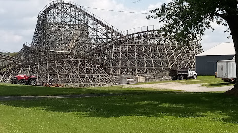
Photo
Where is located Kentucky Rumbler
Kentucky Rumbler — local attraction, which is located at 798 Beech Bend Park Rd, Bowling Green, KY 42101, United States and belongs to the category — roller coaster. Average visitor rating for this place — 4.2 (according to 17 ratings, information from open sources and relevant for 2022).
Exact location — Kentucky Rumbler, marked on the map with a red marker.
You can get directions to Kentucky Rumbler on the map from your location.
What else is interesting in Bowling Green? You can see all the sights if you go to the city page.
Coordinates
Kentucky Rumbler, United States coordinates in decimal format: latitude — 37.022582533436314, longitude — -86.40200277515439. When converted to degrees, minutes, seconds Kentucky Rumbler has the following coordinates: 37°1′21.3 north latitude and -86°24′7.21 east longitude.
Nearby cities
The largest cities that are located nearby:
- Clarksville — 92 km
- Nashville — 93 km
- Evansville — 146 km
- Louisville — 155 km
- Chattanooga — 238 km
- Huntsville — 248 km
- Knoxville — 255 km
- Cincinnati — 290 km
- Indianapolis — 311 km
- Saint Louis — 370 km
- Memphis — 380 km
- Birmingham — 382 km
- Springfield — 398 km
- Atlanta — 405 km
- Columbus — 443 km
- Fort Wayne — 468 km
- Peoria — 487 km
- Montgomery — 509 km
- South Bend — 521 km
Distance to the capital
Distance to the capital (Washington) is about — 847 km.