 Warner Robins
Wantagh
Bethel
Misty Hill Farm
United States
Wakonda Beach (R33) Airport
Wilmington
Poland
Miami International Airport
Warner Robins
Wantagh
Bethel
Misty Hill Farm
United States
Wakonda Beach (R33) Airport
Wilmington
Poland
Miami International Airport
Miramar Regional Public Beach on the map, Destin, United States
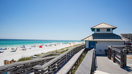
Photo
Where is located Miramar Regional Public Beach
Miramar Regional Public Beach — local attraction, which is located at 2396 Scenic Hwy 98, Miramar Beach, FL 32550, United States and belongs to the category — park. Average visitor rating for this place — 4.8 (according to 522 ratings, information from open sources and relevant for 2022).
Exact location — Miramar Regional Public Beach, marked on the map with a red marker.
You can get directions to Miramar Regional Public Beach on the map from your location.
What else is interesting in Destin? You can see all the sights if you go to the city page.
Coordinates
Miramar Regional Public Beach, United States coordinates in decimal format: latitude — 30.378058330463958, longitude — -86.38753687532764. When converted to degrees, minutes, seconds Miramar Regional Public Beach has the following coordinates: 30°22′41.01 north latitude and -86°23′15.13 east longitude.
Nearby cities
The largest cities that are located nearby:
- Mobile — 151 km
- Tallahassee — 211 km
- Montgomery — 219 km
- New Orleans — 346 km
- Birmingham — 347 km
- Metairie — 353 km
- Jackson — 404 km
- Gainesville — 409 km
- Atlanta — 419 km
- Baton Rouge — 443 km
- Clearwater — 450 km
- Jacksonville — 462 km
- Saint Petersburg — 476 km
- Tampa — 478 km
- Huntsville — 480 km
- Brandon — 493 km
- Chattanooga — 525 km
- Lafayette — 528 km
- Orlando — 538 km
Distance to the capital
Distance to the capital (Washington) is about — 1276 km.