 Warner Robins
Wantagh
Bethel
Misty Hill Farm
United States
Wakonda Beach (R33) Airport
Wilmington
Poland
Miami International Airport
Warner Robins
Wantagh
Bethel
Misty Hill Farm
United States
Wakonda Beach (R33) Airport
Wilmington
Poland
Miami International Airport
The Maritime Museum of Amelia Island on the map, Fernandina Beach, United States
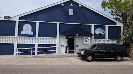
Photo
Where is located The Maritime Museum of Amelia Island
The Maritime Museum of Amelia Island — local attraction, which is located at 115 S 2nd St, Fernandina Beach, FL 32034, United States and belongs to the category — museum. Average visitor rating for this place — 4.6 (according to 58 ratings, information from open sources and relevant for 2022).
Exact location — The Maritime Museum of Amelia Island, marked on the map with a red marker.
You can get directions to The Maritime Museum of Amelia Island on the map from your location.
What else is interesting in Fernandina Beach? You can see all the sights if you go to the city page.
Coordinates
The Maritime Museum of Amelia Island, United States coordinates in decimal format: latitude — 30.669423755057608, longitude — -81.46435197532058. When converted to degrees, minutes, seconds The Maritime Museum of Amelia Island has the following coordinates: 30°40′9.93 north latitude and -81°27′51.67 east longitude.
Nearby cities
The largest cities that are located nearby:
- Jacksonville — 42 km
- Gainesville — 140 km
- Savannah — 160 km
- Orlando — 236 km
- Tallahassee — 270 km
- Charleston — 273 km
- Brandon — 313 km
- Tampa — 316 km
- Clearwater — 326 km
- Saint Petersburg — 340 km
- Columbia — 370 km
- Port Saint Lucie — 391 km
- Atlanta — 434 km
- Cape Coral — 457 km
- Montgomery — 489 km
- Coral Springs — 500 km
- Charlotte — 507 km
- Fort Lauderdale — 520 km
- Pembroke Pines — 528 km
Distance to the capital
Distance to the capital (Washington) is about — 1001 km.