 Warner Robins
Wantagh
Bethel
Misty Hill Farm
United States
Wakonda Beach (R33) Airport
Wilmington
Poland
Miami International Airport
Warner Robins
Wantagh
Bethel
Misty Hill Farm
United States
Wakonda Beach (R33) Airport
Wilmington
Poland
Miami International Airport
St. Marks River Preserve State Park on the map, Tallahassee, United States
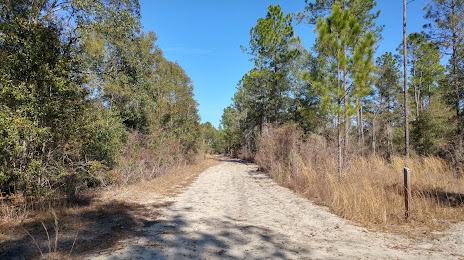
Photo
Where is located St. Marks River Preserve State Park
St. Marks River Preserve State Park — local attraction, which is located at 11950 Tram Rd, Tallahassee, FL 32311, United States and belongs to the category — state park. Average visitor rating for this place — 4.2 (according to 17 ratings, information from open sources and relevant for 2022).
Exact location — St. Marks River Preserve State Park, marked on the map with a red marker.
You can get directions to St. Marks River Preserve State Park on the map from your location.
What else is interesting in Tallahassee? You can see all the sights if you go to the city page.
Coordinates
St. Marks River Preserve State Park, United States coordinates in decimal format: latitude — 30.371557227696258, longitude — -84.0871198753277. When converted to degrees, minutes, seconds St. Marks River Preserve State Park has the following coordinates: 30°22′17.61 north latitude and -84°5′13.63 east longitude.
Nearby cities
The largest cities that are located nearby:
- Gainesville — 207 km
- Jacksonville — 251 km
- Montgomery — 285 km
- Clearwater — 309 km
- Tampa — 328 km
- Saint Petersburg — 336 km
- Brandon — 338 km
- Savannah — 349 km
- Orlando — 351 km
- Mobile — 359 km
- Atlanta — 366 km
- Birmingham — 413 km
- Charleston — 480 km
- Cape Coral — 487 km
- Columbia — 494 km
- Chattanooga — 518 km
- Huntsville — 519 km
- Port Saint Lucie — 521 km
- New Orleans — 557 km
Distance to the capital
Distance to the capital (Washington) is about — 1147 km.