 Warner Robins
Wantagh
Bethel
Misty Hill Farm
United States
Wakonda Beach (R33) Airport
Wilmington
Poland
Miami International Airport
Warner Robins
Wantagh
Bethel
Misty Hill Farm
United States
Wakonda Beach (R33) Airport
Wilmington
Poland
Miami International Airport
Fort Defiance Civil War Park & Interpretive Center on the map, Clarksville, United States
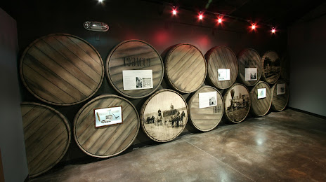
Photo
Where is located Fort Defiance Civil War Park & Interpretive Center
Fort Defiance Civil War Park & Interpretive Center — local attraction, which is located at 120 Duncan St, Clarksville, TN 37042, United States and belongs to the category — history museum. Average visitor rating for this place — 4.5 (according to 315 ratings, information from open sources and relevant for 2022).
Exact location — Fort Defiance Civil War Park & Interpretive Center, marked on the map with a red marker.
You can get directions to Fort Defiance Civil War Park & Interpretive Center on the map from your location.
What else is interesting in Clarksville? You can see all the sights if you go to the city page.
Coordinates
Fort Defiance Civil War Park & Interpretive Center, United States coordinates in decimal format: latitude — 36.54140359075739, longitude — -87.37282447516793. When converted to degrees, minutes, seconds Fort Defiance Civil War Park & Interpretive Center has the following coordinates: 36°32′29.05 north latitude and -87°22′22.17 east longitude.
Nearby cities
The largest cities that are located nearby:
- Nashville — 66 km
- Evansville — 160 km
- Huntsville — 211 km
- Louisville — 236 km
- Chattanooga — 248 km
- Memphis — 287 km
- Knoxville — 314 km
- Birmingham — 337 km
- Saint Louis — 338 km
- Indianapolis — 372 km
- Cincinnati — 375 km
- Atlanta — 411 km
- Montgomery — 471 km
- Springfield — 481 km
- Little Rock — 489 km
- Peoria — 497 km
- Columbus — 530 km
- Fort Wayne — 536 km
- Jackson — 537 km
Distance to the capital
Distance to the capital (Washington) is about — 946 km.