 Warner Robins
Wantagh
Bethel
Misty Hill Farm
United States
Wakonda Beach (R33) Airport
Wilmington
Poland
Miami International Airport
Warner Robins
Wantagh
Bethel
Misty Hill Farm
United States
Wakonda Beach (R33) Airport
Wilmington
Poland
Miami International Airport
Lewisville Regional Park on the map, Battle Ground, United States
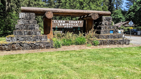
Photo
Where is located Lewisville Regional Park
Lewisville Regional Park — local attraction, which is located at 26411 NE Lewisville Hwy, Battle Ground, WA 98604, United States and belongs to the category — park. Average visitor rating for this place — 4.7 (according to 1526 ratings, information from open sources and relevant for 2022).
Exact location — Lewisville Regional Park, marked on the map with a red marker.
You can get directions to Lewisville Regional Park on the map from your location.
What else is interesting in Battle Ground? You can see all the sights if you go to the city page.
Coordinates
Lewisville Regional Park, United States coordinates in decimal format: latitude — 45.81828643120066, longitude — -122.53994587488128. When converted to degrees, minutes, seconds Lewisville Regional Park has the following coordinates: 45°49′5.83 north latitude and -122°32′23.81 east longitude.
Nearby cities
The largest cities that are located nearby:
- Vancouver — 19 km
- Portland — 31 km
- Salem — 101 km
- Tacoma — 163 km
- Eugene — 196 km
- Seattle — 202 km
- Bellevue — 204 km
- Victoria
 (Canada) — 299 km
 - Abbotsford (Canada) — 362 km
- Delta (Canada) — 368 km
- Richmond (Canada) — 377 km
- Surrey (Canada) — 377 km
- Burnaby (Canada) — 387 km
- Coquitlam (Canada) — 388 km
- Anmore (Canada) — 391 km
- Spokane — 433 km
- Kelowna (Canada) — 503 km
- Boise — 559 km
- Reno — 729 km
Distance to the capital
Distance to the capital (Washington) is about — 3765 km.