 Warner Robins
Wantagh
Bethel
Misty Hill Farm
United States
Wakonda Beach (R33) Airport
Wilmington
Poland
Miami International Airport
Warner Robins
Wantagh
Bethel
Misty Hill Farm
United States
Wakonda Beach (R33) Airport
Wilmington
Poland
Miami International Airport
Roundtop Filling Station on the map, Sherwood, United States
Photo
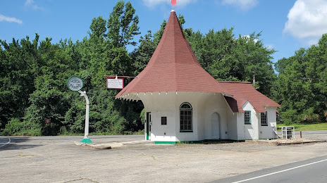
Where is located Roundtop Filling Station
Roundtop Filling Station — local attraction, which is located at Old Hwy 67, North Little Rock, AR 72117, United States and belongs to the category — historical place. Average visitor rating for this place — 5.0 (according to 3 ratings, information from open sources and relevant for 2022).
Exact location — Roundtop Filling Station, marked on the map with a red marker.
You can get directions to Roundtop Filling Station on the map from your location.
What else is interesting in Sherwood? You can see all the sights if you go to the city page.
Coordinates
Roundtop Filling Station, United States coordinates in decimal format: latitude — 34.81227864143345, longitude — -92.17873977521533. When converted to degrees, minutes, seconds Roundtop Filling Station has the following coordinates: 34°48′44.2 north latitude and -92°10′43.46 east longitude.
Nearby cities
The largest cities that are located nearby:
- Little Rock — 10 km
- Memphis — 200 km
- Springfield — 281 km
- Shreveport — 290 km
- Jackson — 337 km
- Tulsa — 368 km
- Saint Louis — 456 km
- Plano — 460 km
- Garland — 461 km
- Frisco — 464 km
- Mesquite — 466 km
- Richardson — 466 km
- Clarksville — 472 km
- Norman — 473 km
- Carrollton — 478 km
- Dallas — 481 km
- Oklahoma City — 482 km
- Denton — 487 km
- Irving — 492 km
Distance to the capital
Distance to the capital (Washington) is about — 1420 km.