 Warner Robins
Wantagh
Bethel
Misty Hill Farm
United States
Wakonda Beach (R33) Airport
Wilmington
Poland
Miami International Airport
Warner Robins
Wantagh
Bethel
Misty Hill Farm
United States
Wakonda Beach (R33) Airport
Wilmington
Poland
Miami International Airport
Lewis & Clark Recreation Area on the map, Yankton, United States
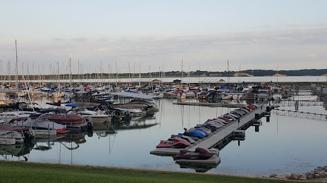
Photo
Where is located Lewis & Clark Recreation Area
Lewis & Clark Recreation Area — local attraction, which is located at 43349 SD-52, Yankton, SD 57078, United States and belongs to the category — state park. Average visitor rating for this place — 4.8 (according to 959 ratings, information from open sources and relevant for 2022).
Exact location — Lewis & Clark Recreation Area, marked on the map with a red marker.
You can get directions to Lewis & Clark Recreation Area on the map from your location.
What else is interesting in Yankton? You can see all the sights if you go to the city page.
Coordinates
Lewis & Clark Recreation Area, United States coordinates in decimal format: latitude — 42.86394234440427, longitude — -97.49080774501779. When converted to degrees, minutes, seconds Lewis & Clark Recreation Area has the following coordinates: 42°51′50.19 north latitude and -97°29′26.91 east longitude.
Nearby cities
The largest cities that are located nearby:
- Sioux Falls — 92 km
- Omaha — 213 km
- Lincoln — 234 km
- Des Moines — 343 km
- Minneapolis — 398 km
- Saint Paul — 408 km
- Topeka — 447 km
- North Kansas City — 478 km
- Kansas City — 482 km
- Overland Park — 490 km
- Independence — 490 km
- Olathe — 494 km
- Wichita — 573 km
- Madison — 646 km
- Rockford — 683 km
- Fort Collins — 693 km
- Peoria — 697 km
- Aurora — 721 km
- Springfield — 723 km
Distance to the capital
Distance to the capital (Washington) is about — 1770 km.