 Warner Robins
Wantagh
Bethel
Misty Hill Farm
United States
Wakonda Beach (R33) Airport
Wilmington
Poland
Miami International Airport
Warner Robins
Wantagh
Bethel
Misty Hill Farm
United States
Wakonda Beach (R33) Airport
Wilmington
Poland
Miami International Airport
Pinnacle Rock State Park on the map, Bluefield, United States
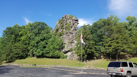
Photo
Where is located Pinnacle Rock State Park
Pinnacle Rock State Park — local attraction, which is located at 6470 Coal Heritage Rd, Bramwell, WV 24715, United States and belongs to the category — state park. Average visitor rating for this place — 4.7 (according to 338 ratings, information from open sources and relevant for 2022).
Exact location — Pinnacle Rock State Park, marked on the map with a red marker.
You can get directions to Pinnacle Rock State Park on the map from your location.
What else is interesting in Bluefield? You can see all the sights if you go to the city page.
Coordinates
Pinnacle Rock State Park, United States coordinates in decimal format: latitude — 37.31773302699394, longitude — -81.29055000457053. When converted to degrees, minutes, seconds Pinnacle Rock State Park has the following coordinates: 37°19′3.84 north latitude and -81°17′25.98 east longitude.
Nearby cities
The largest cities that are located nearby:
- Winston-Salem — 156 km
- Greensboro — 184 km
- Charlotte — 228 km
- Durham — 251 km
- Cary — 273 km
- Knoxville — 282 km
- Raleigh — 284 km
- Fayetteville — 324 km
- Richmond — 333 km
- Columbus — 333 km
- Cincinnati — 347 km
- Columbia — 362 km
- Pittsburgh — 365 km
- Springfield — 366 km
- Alexandria — 398 km
- Louisville — 409 km
- Akron — 422 km
- Hampton — 431 km
- Norfolk — 439 km
Distance to the capital
Distance to the capital (Washington) is about — 412 km.