 Warner Robins
Wantagh
Bethel
Misty Hill Farm
United States
Wakonda Beach (R33) Airport
Wilmington
Poland
Miami International Airport
Warner Robins
Wantagh
Bethel
Misty Hill Farm
United States
Wakonda Beach (R33) Airport
Wilmington
Poland
Miami International Airport
Coachella Valley History Museum on the map, Indio, United States
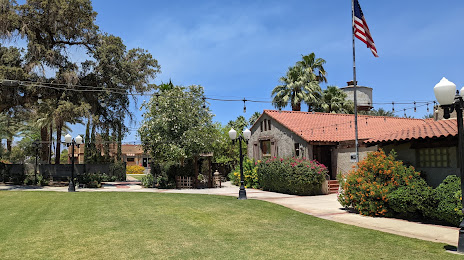
Photo
Where is located Coachella Valley History Museum
Coachella Valley History Museum — local attraction, which is located at 82616 Miles Ave, Indio, CA 92201, United States and belongs to the category — museum. Average visitor rating for this place — 4.6 (according to 97 ratings, information from open sources and relevant for 2022).
Exact location — Coachella Valley History Museum, marked on the map with a red marker.
You can get directions to Coachella Valley History Museum on the map from your location.
What else is interesting in Indio? You can see all the sights if you go to the city page.
Coordinates
Coachella Valley History Museum, United States coordinates in decimal format: latitude — 33.721533124230454, longitude — -116.2231028752443. When converted to degrees, minutes, seconds Coachella Valley History Museum has the following coordinates: 33°43′17.52 north latitude and -116°13′23.17 east longitude.
Nearby cities
The largest cities that are located nearby:
- Moreno Valley — 96 km
- Escondido — 104 km
- San Bernardino — 107 km
- Riverside — 111 km
- Rialto — 114 km
- Fontana — 119 km
- Oceanside — 122 km
- Corona — 125 km
- Rancho Cucamonga — 133 km
- Ontario — 137 km
- Mexicali
 (Mexico) — 141 km
 - San Diego — 142 km
- Chula Vista — 144 km
- Irvine — 145 km
- Pomona — 145 km
- Orange — 151 km
- Santa Ana — 152 km
- Tijuana (Mexico) — 154 km
- Anaheim — 157 km
Distance to the capital
Distance to the capital (Washington) is about — 3532 km.