 Warner Robins
Wantagh
Bethel
Misty Hill Farm
United States
Wakonda Beach (R33) Airport
Wilmington
Poland
Miami International Airport
Warner Robins
Wantagh
Bethel
Misty Hill Farm
United States
Wakonda Beach (R33) Airport
Wilmington
Poland
Miami International Airport
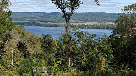
Lake Onalaska on the map, La Crosse, United States
Photo
Where is located Lake Onalaska
Lake Onalaska — local attraction, which is located at 31.11 km² and belongs to the category — -. Average visitor rating for this place — 4.4 (according to 16 ratings, information from open sources and relevant for 2022).
Exact location — Lake Onalaska, marked on the map with a red marker.
You can get directions to Lake Onalaska on the map from your location.
What else is interesting in La Crosse? You can see all the sights if you go to the city page.
Coordinates
Lake Onalaska, United States coordinates in decimal format: latitude — 43.9025542708288, longitude — -91.2999355133377. When converted to degrees, minutes, seconds Lake Onalaska has the following coordinates: 43°54′9.2 north latitude and -91°17′59.77 east longitude.
Nearby cities
The largest cities that are located nearby:
- Madison — 169 km
- Saint Paul — 193 km
- Minneapolis — 205 km
- Rockford — 244 km
- Green Bay — 266 km
- Milwaukee — 282 km
- Des Moines — 312 km
- Aurora — 330 km
- Naperville — 341 km
- Joliet — 363 km
- Chicago — 365 km
- Peoria — 370 km
- Sioux Falls — 441 km
- Grand Rapids — 460 km
- South Bend — 474 km
- Omaha — 486 km
- Lansing — 556 km
- Lincoln — 562 km
- Saint Louis — 579 km
Distance to the capital
Distance to the capital (Washington) is about — 1311 km.