 Warner Robins
Wantagh
Bethel
Misty Hill Farm
United States
Wakonda Beach (R33) Airport
Wilmington
Poland
Miami International Airport
Warner Robins
Wantagh
Bethel
Misty Hill Farm
United States
Wakonda Beach (R33) Airport
Wilmington
Poland
Miami International Airport
Falls Fire Barn Museum on the map, Attleboro, United States
Photo
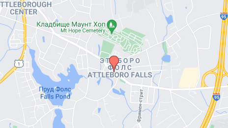
Where is located Falls Fire Barn Museum
Falls Fire Barn Museum — local attraction, which is located at 100 Commonwealth Ave, North Attleborough, MA 02763, United States and belongs to the category — museum. Average visitor rating for this place — 4.0 (according to 1 rating, information from open sources and relevant for 2022).
Exact location — Falls Fire Barn Museum, marked on the map with a red marker.
You can get directions to Falls Fire Barn Museum on the map from your location.
What else is interesting in Attleboro? You can see all the sights if you go to the city page.
Coordinates
Falls Fire Barn Museum, United States coordinates in decimal format: latitude — 41.97116448411633, longitude — -71.3139910750065. When converted to degrees, minutes, seconds Falls Fire Barn Museum has the following coordinates: 41°58′16.19 north latitude and -71°18′50.37 east longitude.
Nearby cities
The largest cities that are located nearby:
- Providence — 17 km
- Boston — 50 km
- Cambridge — 50 km
- Worcester — 55 km
- Lowell — 76 km
- Amherst — 108 km
- Springfield — 108 km
- Manchester — 117 km
- Hartford — 117 km
- Waterbury — 152 km
- New Haven — 153 km
- Bridgeport — 180 km
- Stamford — 212 km
- Yonkers — 245 km
- New York — 266 km
- Brooklyn — 266 km
- Paterson — 267 km
- Newark — 276 km
- Elizabeth — 283 km
Distance to the capital
Distance to the capital (Washington) is about — 592 km.