 Warner Robins
Wantagh
Bethel
Misty Hill Farm
United States
Wakonda Beach (R33) Airport
Wilmington
Poland
Miami International Airport
Warner Robins
Wantagh
Bethel
Misty Hill Farm
United States
Wakonda Beach (R33) Airport
Wilmington
Poland
Miami International Airport
Henry Church Rock Picnic Area on the map, Twinsburg, United States
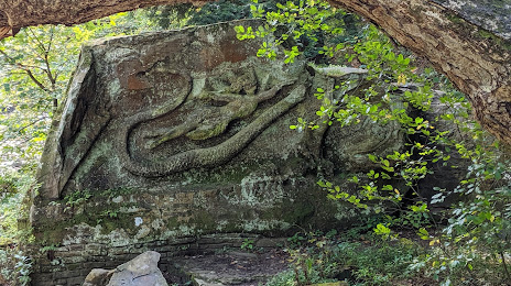
Photo
Where is located Henry Church Rock Picnic Area
Henry Church Rock Picnic Area — local attraction, which is located at Hawthorn Pkwy, Bentleyville, OH 44022, United States and belongs to the category — park. Average visitor rating for this place — 4.6 (according to 170 ratings, information from open sources and relevant for 2022).
Exact location — Henry Church Rock Picnic Area, marked on the map with a red marker.
You can get directions to Henry Church Rock Picnic Area on the map from your location.
What else is interesting in Twinsburg? You can see all the sights if you go to the city page.
Coordinates
Henry Church Rock Picnic Area, United States coordinates in decimal format: latitude — 41.315030382608555, longitude — -81.44615199988675. When converted to degrees, minutes, seconds Henry Church Rock Picnic Area has the following coordinates: 41°18′54.11 north latitude and -81°26′46.15 east longitude.
Nearby cities
The largest cities that are located nearby:
- Aurora — 8 km
- Akron — 26 km
- Cleveland — 29 km
- Pittsburgh — 155 km
- Windsor
 (Canada) — 171 km
 - Detroit — 173 km
- Toledo — 179 km
- Warren — 185 km
- London (Canada) — 186 km
- Sterling Heights — 191 km
- Columbus — 199 km
- Ann Arbor — 217 km
- Cambridge (Canada) — 244 km
- Kitchener (Canada) — 245 km
- Hamilton (Canada) — 249 km
- Waterloo (Canada) — 249 km
- Springfield — 253 km
- Burlington (Canada) — 259 km
- Flint — 261 km
Distance to the capital
Distance to the capital (Washington) is about — 461 km.