 Warner Robins
Wantagh
Bethel
Misty Hill Farm
United States
Wakonda Beach (R33) Airport
Wilmington
Poland
Miami International Airport
Warner Robins
Wantagh
Bethel
Misty Hill Farm
United States
Wakonda Beach (R33) Airport
Wilmington
Poland
Miami International Airport
Ox Bow Park on the map, Elkhart, United States
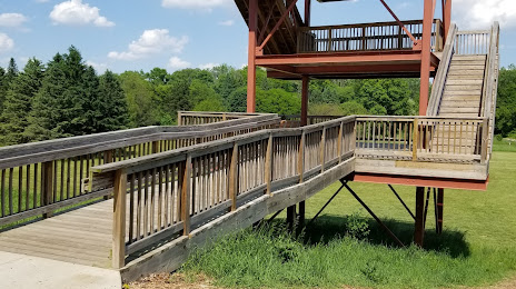
Photo
Where is located Ox Bow Park
Ox Bow Park — local attraction, which is located at 23033 Co Rd 45, Goshen, IN 46528, United States and belongs to the category — park. Average visitor rating for this place — 4.7 (according to 998 ratings, information from open sources and relevant for 2022).
Exact location — Ox Bow Park, marked on the map with a red marker.
You can get directions to Ox Bow Park on the map from your location.
What else is interesting in Elkhart? You can see all the sights if you go to the city page.
Coordinates
Ox Bow Park, United States coordinates in decimal format: latitude — 41.62893489193184, longitude — -85.90615707501728. When converted to degrees, minutes, seconds Ox Bow Park has the following coordinates: 41°37′44.17 north latitude and -85°54′22.17 east longitude.
Nearby cities
The largest cities that are located nearby:
- South Bend — 23 km
- Fort Wayne — 96 km
- Chicago — 138 km
- Grand Rapids — 144 km
- Lansing — 164 km
- Joliet — 175 km
- Naperville — 180 km
- Aurora — 193 km
- Ann Arbor — 194 km
- Toledo — 200 km
- Indianapolis — 212 km
- Milwaukee — 216 km
- Flint — 236 km
- Detroit — 250 km
- Windsor
 (Canada) — 250 km
 - Warren — 258 km
- Sterling Heights — 260 km
- Rockford — 263 km
- Springfield — 268 km
Distance to the capital
Distance to the capital (Washington) is about — 811 km.