 Warner Robins
Wantagh
Bethel
Misty Hill Farm
United States
Wakonda Beach (R33) Airport
Wilmington
Poland
Miami International Airport
Warner Robins
Wantagh
Bethel
Misty Hill Farm
United States
Wakonda Beach (R33) Airport
Wilmington
Poland
Miami International Airport
Cherokee Run Golf Club on the map, Conyers, United States
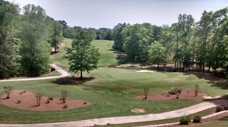
Photo
Where is located Cherokee Run Golf Club
Cherokee Run Golf Club — local attraction, which is located at 1595 Centennial Olympic Pkwy NE, Conyers, GA 30013, United States and belongs to the category — golf course. Average visitor rating for this place — 4.6 (according to 246 ratings, information from open sources and relevant for 2022).
Exact location — Cherokee Run Golf Club, marked on the map with a red marker.
You can get directions to Cherokee Run Golf Club on the map from your location.
What else is interesting in Conyers? You can see all the sights if you go to the city page.
Coordinates
Cherokee Run Golf Club, United States coordinates in decimal format: latitude — 33.67879980426302, longitude — -83.94610277524528. When converted to degrees, minutes, seconds Cherokee Run Golf Club has the following coordinates: 33°40′43.68 north latitude and -83°56′45.97 east longitude.
Nearby cities
The largest cities that are located nearby:
- Atlanta — 35 km
- Chattanooga — 192 km
- Knoxville — 254 km
- Montgomery — 257 km
- Birmingham — 257 km
- Huntsville — 261 km
- Columbia — 276 km
- Savannah — 325 km
- Charlotte — 335 km
- Tallahassee — 358 km
- Nashville — 370 km
- Charleston — 392 km
- Winston-Salem — 431 km
- Jacksonville — 432 km
- Clarksville — 434 km
- Greensboro — 462 km
- Gainesville — 473 km
- Fayetteville — 490 km
- Mobile — 504 km
Distance to the capital
Distance to the capital (Washington) is about — 849 km.