 Warner Robins
Wantagh
Bethel
Misty Hill Farm
United States
Wakonda Beach (R33) Airport
Wilmington
Poland
Miami International Airport
Warner Robins
Wantagh
Bethel
Misty Hill Farm
United States
Wakonda Beach (R33) Airport
Wilmington
Poland
Miami International Airport
Sandy Point Island on the map, Westerly, United States
Photo
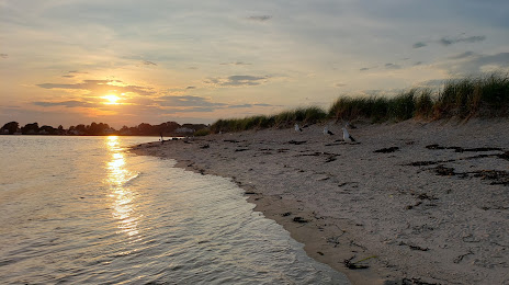
Where is located Sandy Point Island
Sandy Point Island — local attraction, which is located at no data and belongs to the category — -. Average visitor rating for this place — 5.0 (according to 20 ratings, information from open sources and relevant for 2022).
Exact location — Sandy Point Island, marked on the map with a red marker.
You can get directions to Sandy Point Island on the map from your location.
What else is interesting in Westerly? You can see all the sights if you go to the city page.
Coordinates
Sandy Point Island, United States coordinates in decimal format: latitude — 41.32651194405737, longitude — -71.88821202433829. When converted to degrees, minutes, seconds Sandy Point Island has the following coordinates: 41°19′35.44 north latitude and -71°53′17.56 east longitude.
Nearby cities
The largest cities that are located nearby:
- Providence — 60 km
- Hartford — 83 km
- New Haven — 92 km
- Worcester — 98 km
- Springfield — 102 km
- Waterbury — 103 km
- Bridgeport — 116 km
- Amherst — 120 km
- Cambridge — 125 km
- Boston — 125 km
- Lowell — 145 km
- Stamford — 147 km
- Yonkers — 180 km
- Manchester — 181 km
- Brooklyn — 197 km
- New York — 197 km
- Paterson — 202 km
- Newark — 209 km
- Elizabeth — 215 km
Distance to the capital
Distance to the capital (Washington) is about — 514 km.