 Warner Robins
Wantagh
Bethel
Misty Hill Farm
United States
Wakonda Beach (R33) Airport
Wilmington
Poland
Miami International Airport
Warner Robins
Wantagh
Bethel
Misty Hill Farm
United States
Wakonda Beach (R33) Airport
Wilmington
Poland
Miami International Airport
Jesse James Farm and Museum on the map, Excelsior Springs, United States
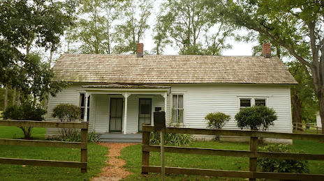
Photo
Where is located Jesse James Farm and Museum
Jesse James Farm and Museum — local attraction, which is located at 21216 Jesse James Farm Rd, Kearney, MO 64060, United States and belongs to the category — history museum. Average visitor rating for this place — 4.7 (according to 13 ratings, information from open sources and relevant for 2022).
Exact location — Jesse James Farm and Museum, marked on the map with a red marker.
You can get directions to Jesse James Farm and Museum on the map from your location.
What else is interesting in Excelsior Springs? You can see all the sights if you go to the city page.
Coordinates
Jesse James Farm and Museum, United States coordinates in decimal format: latitude — 39.39305546840078, longitude — -94.32172977508556. When converted to degrees, minutes, seconds Jesse James Farm and Museum has the following coordinates: 39°23′35 north latitude and -94°19′18.23 east longitude.
Nearby cities
The largest cities that are located nearby:
- Independence — 32 km
- North Kansas City — 37 km
- Kansas City — 40 km
- Overland Park — 55 km
- Olathe — 72 km
- Topeka — 129 km
- Springfield — 249 km
- Des Moines — 255 km
- Omaha — 258 km
- Lincoln — 263 km
- Wichita — 328 km
- Saint Louis — 357 km
- Tulsa — 386 km
- Peoria — 417 km
- Sioux Falls — 506 km
- Oklahoma City — 521 km
- Rockford — 530 km
- Little Rock — 537 km
- Norman — 540 km
Distance to the capital
Distance to the capital (Washington) is about — 1490 km.