 Warner Robins
Wantagh
Bethel
Misty Hill Farm
United States
Wakonda Beach (R33) Airport
Wilmington
Poland
Miami International Airport
Warner Robins
Wantagh
Bethel
Misty Hill Farm
United States
Wakonda Beach (R33) Airport
Wilmington
Poland
Miami International Airport
Whitehorse County Park on the map, Grants Pass, United States
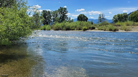
Photo
Where is located Whitehorse County Park
Whitehorse County Park — local attraction, which is located at 7613 Lower River Rd, Grants Pass, OR 97526, United States and belongs to the category — park. Average visitor rating for this place — 4.2 (according to 223 ratings, information from open sources and relevant for 2022).
Exact location — Whitehorse County Park, marked on the map with a red marker.
You can get directions to Whitehorse County Park on the map from your location.
What else is interesting in Grants Pass? You can see all the sights if you go to the city page.
Coordinates
Whitehorse County Park, United States coordinates in decimal format: latitude — 42.436837347682506, longitude — -123.45885537499184. When converted to degrees, minutes, seconds Whitehorse County Park has the following coordinates: 42°26′12.61 north latitude and -123°27′31.88 east longitude.
Nearby cities
The largest cities that are located nearby:
- Eugene — 179 km
- Salem — 278 km
- Portland — 345 km
- Vancouver — 357 km
- Reno — 440 km
- Roseville — 444 km
- Santa Rosa — 445 km
- Sacramento — 455 km
- Fairfield — 477 km
- Vallejo — 488 km
- Concord — 506 km
- Richmond — 507 km
- Berkeley — 513 km
- Oakland — 521 km
- San Francisco — 522 km
- Stockton — 526 km
- Tacoma — 536 km
- Hayward — 539 km
- Fremont — 553 km
Distance to the capital
Distance to the capital (Washington) is about — 3887 km.