 Warner Robins
Wantagh
Bethel
Misty Hill Farm
United States
Wakonda Beach (R33) Airport
Wilmington
Poland
Miami International Airport
Warner Robins
Wantagh
Bethel
Misty Hill Farm
United States
Wakonda Beach (R33) Airport
Wilmington
Poland
Miami International Airport
Chuck Lennon Park on the map, DeLand, United States
Photo
Where is located Chuck Lennon Park
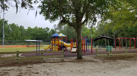
Chuck Lennon Park — local attraction, which is located at 5000 Greenfield Dairy Rd, De Leon Springs, FL 32130, United States and belongs to the category — park. Average visitor rating for this place — 4.7 (according to 208 ratings, information from open sources and relevant for 2022).
Exact location — Chuck Lennon Park, marked on the map with a red marker.
You can get directions to Chuck Lennon Park on the map from your location.
What else is interesting in DeLand? You can see all the sights if you go to the city page.
Coordinates
Chuck Lennon Park, United States coordinates in decimal format: latitude — 29.12459760680465, longitude — -81.3641333753568. When converted to degrees, minutes, seconds Chuck Lennon Park has the following coordinates: 29°7′28.55 north latitude and -81°21′50.88 east longitude.
Nearby cities
The largest cities that are located nearby:
- Orlando — 55 km
- Gainesville — 120 km
- Jacksonville — 148 km
- Brandon — 154 km
- Tampa — 164 km
- Clearwater — 188 km
- Saint Petersburg — 191 km
- Port Saint Lucie — 215 km
- Cape Coral — 280 km
- Coral Springs — 322 km
- Tallahassee — 324 km
- Savannah — 338 km
- Fort Lauderdale — 341 km
- Pembroke Pines — 349 km
- Miramar — 351 km
- Hollywood — 353 km
- Hialeah — 365 km
- Miami — 378 km
- Charleston — 434 km
Distance to the capital
Distance to the capital (Washington) is about — 1159 km.