 Warner Robins
Wantagh
Bethel
Misty Hill Farm
United States
Wakonda Beach (R33) Airport
Wilmington
Poland
Miami International Airport
Warner Robins
Wantagh
Bethel
Misty Hill Farm
United States
Wakonda Beach (R33) Airport
Wilmington
Poland
Miami International Airport
Cernan Earth & Space Center on the map, Park Ridge, United States
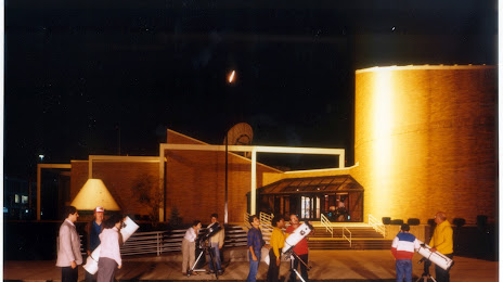
Photo
Where is located Cernan Earth & Space Center
Cernan Earth & Space Center — local attraction, which is located at 2000 5th Ave, River Grove, IL 60171, United States and belongs to the category — planetarium. Average visitor rating for this place — 4.9 (according to 14 ratings, information from open sources and relevant for 2022).
Exact location — Cernan Earth & Space Center, marked on the map with a red marker.
You can get directions to Cernan Earth & Space Center on the map from your location.
What else is interesting in Park Ridge? You can see all the sights if you go to the city page.
Coordinates
Cernan Earth & Space Center, United States coordinates in decimal format: latitude — 41.91727505376847, longitude — -87.84253737500822. When converted to degrees, minutes, seconds Cernan Earth & Space Center has the following coordinates: 41°55′2.19 north latitude and -87°50′33.13 east longitude.
Nearby cities
The largest cities that are located nearby:
- Chicago — 23 km
- Naperville — 39 km
- Aurora — 48 km
- Joliet — 57 km
- Rockford — 107 km
- Milwaukee — 114 km
- South Bend — 136 km
- Madison — 172 km
- Grand Rapids — 205 km
- Peoria — 207 km
- Fort Wayne — 248 km
- Green Bay — 278 km
- Lansing — 278 km
- Indianapolis — 286 km
- Ann Arbor — 337 km
- Flint — 354 km
- Toledo — 356 km
- Detroit — 394 km
- Windsor
 (Canada) — 394 km
Distance to the capital
Distance to the capital (Washington) is about — 974 km.