 Warner Robins
Wantagh
Bethel
Misty Hill Farm
United States
Wakonda Beach (R33) Airport
Wilmington
Poland
Miami International Airport
Warner Robins
Wantagh
Bethel
Misty Hill Farm
United States
Wakonda Beach (R33) Airport
Wilmington
Poland
Miami International Airport
Sedalia Parks & Recreation Department on the map, Sedalia, United States
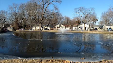
Photo
Where is located Sedalia Parks & Recreation Department
Sedalia Parks & Recreation Department — local attraction, which is located at 1500 W 3rd St, Sedalia, MO 65301, United States and belongs to the category — park. Average visitor rating for this place — 4.4 (according to 64 ratings, information from open sources and relevant for 2022).
Exact location — Sedalia Parks & Recreation Department, marked on the map with a red marker.
You can get directions to Sedalia Parks & Recreation Department on the map from your location.
What else is interesting in Sedalia? You can see all the sights if you go to the city page.
Coordinates
Sedalia Parks & Recreation Department, United States coordinates in decimal format: latitude — 38.700692866078604, longitude — -93.2277931183676. When converted to degrees, minutes, seconds Sedalia Parks & Recreation Department has the following coordinates: 38°42′2.49 north latitude and -93°13′40.06 east longitude.
Nearby cities
The largest cities that are located nearby:
- Independence — 110 km
- Kansas City — 124 km
- North Kansas City — 125 km
- Overland Park — 128 km
- Olathe — 138 km
- Springfield — 165 km
- Topeka — 215 km
- Saint Louis — 262 km
- Des Moines — 322 km
- Omaha — 364 km
- Lincoln — 372 km
- Tulsa — 375 km
- Peoria — 376 km
- Wichita — 377 km
- Little Rock — 446 km
- Memphis — 487 km
- Evansville — 500 km
- Rockford — 520 km
- Oklahoma City — 526 km
Distance to the capital
Distance to the capital (Washington) is about — 1402 km.