 Warner Robins
Wantagh
Bethel
Misty Hill Farm
United States
Wakonda Beach (R33) Airport
Wilmington
Poland
Miami International Airport
Warner Robins
Wantagh
Bethel
Misty Hill Farm
United States
Wakonda Beach (R33) Airport
Wilmington
Poland
Miami International Airport
Kaysville East Mountain Wilderness Park Trail on the map, Layton, United States
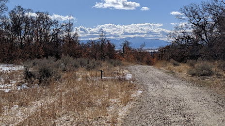
Photo
Where is located Kaysville East Mountain Wilderness Park Trail
Kaysville East Mountain Wilderness Park Trail — local attraction, which is located at 1599 E 650 N, Kaysville, UT 84037, United States and belongs to the category — park. Average visitor rating for this place — 4.5 (according to 79 ratings, information from open sources and relevant for 2022).
Exact location — Kaysville East Mountain Wilderness Park Trail, marked on the map with a red marker.
You can get directions to Kaysville East Mountain Wilderness Park Trail on the map from your location.
What else is interesting in Layton? You can see all the sights if you go to the city page.
Coordinates
Kaysville East Mountain Wilderness Park Trail, United States coordinates in decimal format: latitude — 41.04677006797618, longitude — -111.90509137503531. When converted to degrees, minutes, seconds Kaysville East Mountain Wilderness Park Trail has the following coordinates: 41°2′48.37 north latitude and -111°54′18.33 east longitude.
Nearby cities
The largest cities that are located nearby:
- Salt Lake City — 34 km
- West Valley City — 41 km
- West Jordan — 50 km
- Provo — 95 km
- Boise — 442 km
- Fort Collins — 581 km
- Arvada — 601 km
- Westminster — 604 km
- Lakewood — 605 km
- North Las Vegas — 606 km
- Thornton — 608 km
- Las Vegas — 610 km
- Denver — 611 km
- Henderson — 617 km
- Spring Valley — 621 km
- Aurora — 625 km
- Colorado Springs — 663 km
- Reno — 690 km
- Pueblo — 710 km
Distance to the capital
Distance to the capital (Washington) is about — 2962 km.