 Warner Robins
Wantagh
Bethel
Misty Hill Farm
United States
Wakonda Beach (R33) Airport
Wilmington
Poland
Miami International Airport
Warner Robins
Wantagh
Bethel
Misty Hill Farm
United States
Wakonda Beach (R33) Airport
Wilmington
Poland
Miami International Airport
Sonora Wings Hang Gliding on the map, Casa Grande, United States
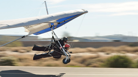
Photo
Where is located Sonora Wings Hang Gliding
Sonora Wings Hang Gliding — local attraction, which is located at 11934 N Russell Rd, Maricopa, AZ 85138, United States and belongs to the category — hang gliding center. Average visitor rating for this place — 4.9 (according to 26 ratings, information from open sources and relevant for 2022).
Exact location — Sonora Wings Hang Gliding, marked on the map with a red marker.
You can get directions to Sonora Wings Hang Gliding on the map from your location.
What else is interesting in Casa Grande? You can see all the sights if you go to the city page.
Coordinates
Sonora Wings Hang Gliding, United States coordinates in decimal format: latitude — 32.98812868507335, longitude — -111.91276247535771. When converted to degrees, minutes, seconds Sonora Wings Hang Gliding has the following coordinates: 32°59′17.26 north latitude and -111°54′45.94 east longitude.
Nearby cities
The largest cities that are located nearby:
- Chandler — 48 km
- Gilbert — 52 km
- Mesa — 60 km
- Tempe — 63 km
- Phoenix — 69 km
- Scottsdale — 70 km
- Glendale — 83 km
- Peoria — 89 km
- Tucson — 106 km
- Nogales — 187 km
- San Luis Río Colorado
 (Mexico) — 285 km
 - Mexicali (Mexico) — 345 km
- Hermosillo (Mexico) — 428 km
- Henderson — 453 km
- Ensenada (Mexico) — 469 km
- Las Vegas — 473 km
- Spring Valley — 474 km
- North Las Vegas — 474 km
- Tijuana (Mexico) — 494 km
Distance to the capital
Distance to the capital (Washington) is about — 3188 km.