 Irvine
Warren
Belvidere
Grand Island
Angola
Fredonia
Sikeston
Felton
Falfurrias
Sheboygan
Exeter
Sheboygan Falls
Brown Deer
Oak Creek
Villa Park
Green Bay
Kilgore
Pleasant Prairie
Oshkosh
Irvine
Warren
Belvidere
Grand Island
Angola
Fredonia
Sikeston
Felton
Falfurrias
Sheboygan
Exeter
Sheboygan Falls
Brown Deer
Oak Creek
Villa Park
Green Bay
Kilgore
Pleasant Prairie
Oshkosh
Janesville on the map, United States
Where is located Janesville
Exact location — Janesville, Rock County, Wisconsin, United States, marked on the map with a red marker.
Coordinates
Janesville, United States coordinates in decimal format: latitude — 42.6827885, longitude — -89.0187222. When converted to degrees, minutes, seconds Janesville has the following coordinates: 42°40′58.04 north latitude and -89°1′7.4 east longitude.
Population
Janesville, Rock County, Wisconsin, United States, according to our data the population is — 61,675 residents, which is about 0% of the total population of the country (United States).
Comparison of the population on the graph:
Exact time
Time zone for this location Janesville — UTC -5 America/Chicago. Exact time — friday, 4 april 2024 year, 18 h. 46 minutes.
Sunrise and sunset
Janesville, sunrise and sunset data for a date — friday 19.04.2024.
| Sunrise | Sunset | Day (duration) |
|---|---|---|
| 06:10 -1 minute | 19:39 +1 minute | 13 h. 30 minutes. +2 minutes |
You can control the scale of the map using the auxiliary tools to find out exactly where it is located Janesville. When you change the scale of the map, the width of the ruler also changes (in kilometers and miles).
Nearby cities
The largest cities that are located nearby:
- Rockford — 46 km
- Madison — 53 km
- Milwaukee — 98 km
- Aurora — 117 km
- Naperville — 125 km
- Chicago — 145 km
- Joliet — 150 km
- Green Bay — 218 km
- Peoria — 225 km
- South Bend — 254 km
- Grand Rapids — 273 km
- Lansing — 363 km
- Fort Wayne — 369 km
- Des Moines — 398 km
- Indianapolis — 404 km
- Saint Paul — 406 km
- Minneapolis — 418 km
- Flint — 433 km
- Ann Arbor — 434 km
Distance to neighboring capitals:
- Ottawa
 (Canada) — 1106 km
 - Mexico City
 (Mexico) — 2755 km
 - Belmopan
 (Belize) — 2829 km
 - Guatemala City
 (Guatemala) — 3125 km
 - Nuuk
 (Greenland) — 3349 km
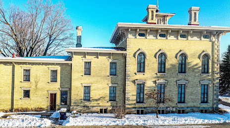
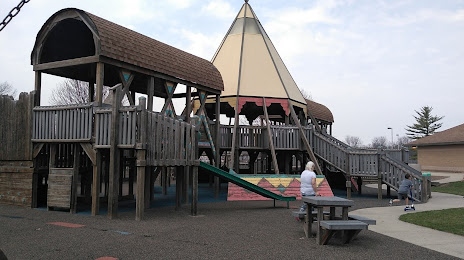
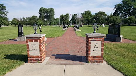
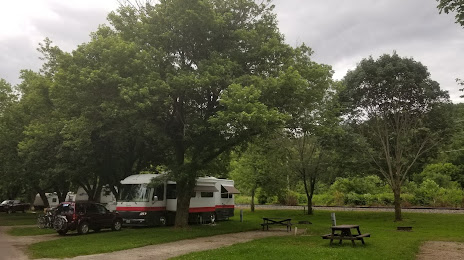
Attractions


Distance to the capital
Distance to the capital (Washington) is about — 1092 km.