 Nevada City
Strasburg
Woodcliff Lake
Ames
Titusville
Clairton
Irwin
Oil City
Mars
DeForest
Woodway
Abilene
Hewitt
Borger
Springtown
Pine Brook
Towanda
Pottsville
Hawk Point
Nevada City
Strasburg
Woodcliff Lake
Ames
Titusville
Clairton
Irwin
Oil City
Mars
DeForest
Woodway
Abilene
Hewitt
Borger
Springtown
Pine Brook
Towanda
Pottsville
Hawk Point
Uniontown on the map, United States
Where is located Uniontown
Exact location — Uniontown, Fayette County, Pennsylvania, United States, marked on the map with a red marker.
Coordinates
Uniontown, United States coordinates in decimal format: latitude — 39.900076, longitude — -79.7164326. When converted to degrees, minutes, seconds Uniontown has the following coordinates: 39°54′0.27 north latitude and -79°42′59.16 east longitude.
Population
Uniontown, Fayette County, Pennsylvania, United States, according to our data the population is — 11,878 residents, which is about 0% of the total population of the country (United States).
Comparison of the population on the graph:
Exact time
Time zone for this location Uniontown — UTC -4 America/New_York. Exact time — thursday, 4 april 2024 year, 03 h. 30 minutes.
Sunrise and sunset
Uniontown, sunrise and sunset data for a date — thursday 25.04.2024.
| Sunrise | Sunset | Day (duration) |
|---|---|---|
| 06:28 -2 minutes | 20:04 +1 minute | 13 h. 36 minutes. +3 minutes |
You can control the scale of the map using the auxiliary tools to find out exactly where it is located Uniontown. When you change the scale of the map, the width of the ruler also changes (in kilometers and miles).
Nearby cities
The largest cities that are located nearby:
- Pittsburgh — 64 km
- Akron — 199 km
- Aurora — 207 km
- Cleveland — 241 km
- Alexandria — 260 km
- Baltimore — 274 km
- Columbus — 278 km
- Boston — 312 km
- Richmond — 329 km
- Buffalo — 337 km
- Springfield — 347 km
- Amherst — 348 km
- Saint Catharines
 (Canada) — 362 km
 - London (Canada) — 363 km
- Allentown — 363 km
- Hamilton (Canada) — 371 km
- Toledo — 372 km
- Burlington (Canada) — 379 km
- Windsor (Canada) — 381 km
Distance to neighboring capitals:
- Ottawa (Canada) — 696 km
- Belmopan
 (Belize) — 2666 km
 - Mexico City
 (Mexico) — 2936 km
 - Guatemala City
 (Guatemala) — 3003 km
 - Nuuk
 (Greenland) — 3253 km
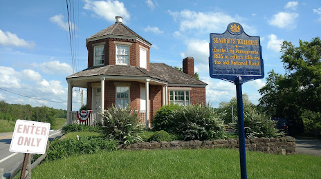
Attractions
Distance to the capital
Distance to the capital (Washington) is about — 255 km.