 Sudbury
Portland
Twinsburg
Lee County
Eureka Airport
Hico
Mount Clemens
Fenton
Bad Axe
Sun Prairie
Marshfield
Platteville
Mosinee
Freeport
La Crosse
Wisconsin Rapids
Middleton
Tomah
Brodhead
Sudbury
Portland
Twinsburg
Lee County
Eureka Airport
Hico
Mount Clemens
Fenton
Bad Axe
Sun Prairie
Marshfield
Platteville
Mosinee
Freeport
La Crosse
Wisconsin Rapids
Middleton
Tomah
Brodhead
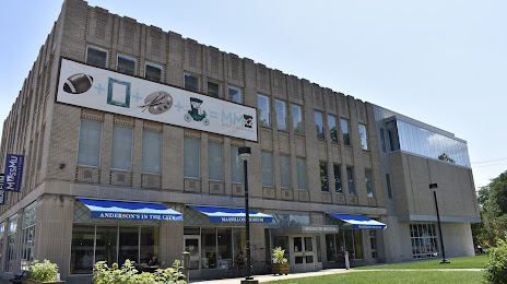
Massillon on the map, United States
Where is located Massillon
Exact location — Massillon, Stark County, Ohio, United States, marked on the map with a red marker.
Coordinates
Massillon, United States coordinates in decimal format: latitude — 40.7967244, longitude — -81.5215093. When converted to degrees, minutes, seconds Massillon has the following coordinates: 40°47′48.21 north latitude and -81°31′17.43 east longitude.
Population
Massillon, Stark County, Ohio, United States, according to our data the population is — 31,526 residents, which is about 0% of the total population of the country (United States).
Comparison of the population on the graph:
Exact time
Time zone for this location Massillon — UTC -4 America/New_York. Exact time — thursday, 4 april 2024 year, 12 h. 57 minutes.
Sunrise and sunset
Massillon, sunrise and sunset data for a date — thursday 18.04.2024.
| Sunrise | Sunset | Day (duration) |
|---|---|---|
| 06:44 -2 minutes | 20:06 +2 minutes | 13 h. 24 minutes. +4 minutes |
You can control the scale of the map using the auxiliary tools to find out exactly where it is located Massillon. When you change the scale of the map, the width of the ruler also changes (in kilometers and miles).
Nearby cities
The largest cities that are located nearby:
- Akron — 31 km
- Aurora — 59 km
- Cleveland — 79 km
- Pittsburgh — 134 km
- Columbus — 156 km
- Toledo — 193 km
- Windsor
 (Canada) — 209 km
 - Detroit — 211 km
- Springfield — 217 km
- Warren — 226 km
- Sterling Heights — 232 km
- London (Canada) — 243 km
- Ann Arbor — 245 km
- Cambridge (Canada) — 300 km
- Flint — 301 km
- Kitchener (Canada) — 301 km
- Hamilton (Canada) — 302 km
- Fort Wayne — 303 km
- Boston — 304 km
Distance to neighboring capitals:
- Ottawa (Canada) — 698 km
- Belmopan
 (Belize) — 2709 km
 - Mexico City
 (Mexico) — 2906 km
 - Guatemala City
 (Guatemala) — 3040 km
 - Nuuk
 (Greenland) — 3229 km
Attractions


Distance to the capital
Distance to the capital (Washington) is about — 437 km.