 Brazil
Stevensville
Madisonville
Tsaile
Stanwood
Radcliff
Fountain Hills
Lacon
Cedartown
Centreville
LaMoure
Romeo State Airport
Wasco
Reedsburg
West Coxsackie
Hickory Flat
Freeland
Millbrook
Saint Joseph
Brazil
Stevensville
Madisonville
Tsaile
Stanwood
Radcliff
Fountain Hills
Lacon
Cedartown
Centreville
LaMoure
Romeo State Airport
Wasco
Reedsburg
West Coxsackie
Hickory Flat
Freeland
Millbrook
Saint Joseph
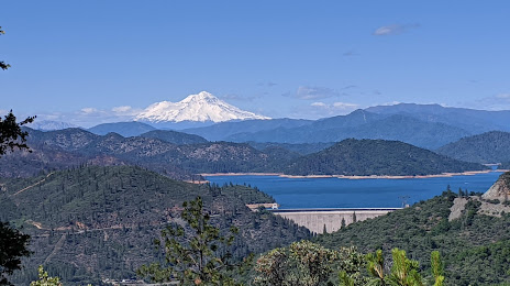
Shasta Lake on the map, United States
Where is located Shasta Lake
Exact location — Shasta Lake, Shasta County, California, United States, marked on the map with a red marker.
Coordinates
Shasta Lake, United States coordinates in decimal format: latitude — 40.6804279, longitude — -122.3708419. When converted to degrees, minutes, seconds Shasta Lake has the following coordinates: 40°40′49.54 north latitude and -122°22′15.03 east longitude.
Population
Shasta Lake, Shasta County, California, United States, according to our data the population is — 10,611 residents, which is about 0% of the total population of the country (United States).
Comparison of the population on the graph:
Exact time
Time zone for this location Shasta Lake — UTC -7 America/Los_Angeles. Exact time — thursday, 4 april 2024 year, 16 h. 36 minutes.
Sunrise and sunset
Shasta Lake, sunrise and sunset data for a date — thursday 25.04.2024.
| Sunrise | Sunset | Day (duration) |
|---|---|---|
| 06:18 -1 minute | 19:56 +1 minute | 13 h. 36 minutes. +2 minutes |
You can control the scale of the map using the auxiliary tools to find out exactly where it is located Shasta Lake. When you change the scale of the map, the width of the ruler also changes (in kilometers and miles).
Nearby cities
The largest cities that are located nearby:
- Roseville — 233 km
- Sacramento — 244 km
- Santa Rosa — 249 km
- Reno — 252 km
- Fairfield — 270 km
- Vallejo — 285 km
- Concord — 300 km
- Richmond — 306 km
- Berkeley — 311 km
- Stockton — 315 km
- Oakland — 318 km
- San Francisco — 321 km
- Hayward — 334 km
- Fremont — 348 km
- Modesto — 357 km
- Sunnyvale — 367 km
- Santa Clara — 370 km
- San Jose — 372 km
- Eugene — 377 km
Distance to neighboring capitals:
- Mexico City
 (Mexico) — 3234 km
 - Ottawa
 (Canada) — 3776 km
 - Belmopan
 (Belize) — 4138 km
 - Guatemala City
 (Guatemala) — 4228 km
 - Nuuk
 (Greenland) — 5102 km
Attractions


Distance to the capital
Distance to the capital (Washington) is about — 3836 km.