 Cochiti
Moorhead
Gambier
Greenup
Russell County
Gloucester Point
Wilmore
Paint Lick
Burkesville
North Tonawanda
Warsaw
Yorktown Heights
Prairie View
Socorro
Dahlgren
Potsdam
Senatobia
Montevallo
Delano
Cochiti
Moorhead
Gambier
Greenup
Russell County
Gloucester Point
Wilmore
Paint Lick
Burkesville
North Tonawanda
Warsaw
Yorktown Heights
Prairie View
Socorro
Dahlgren
Potsdam
Senatobia
Montevallo
Delano
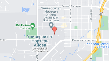
Cedar Falls on the map, United States
Where is located Cedar Falls
Exact location — Cedar Falls, Black Hawk County, Iowa, United States, marked on the map with a red marker.
Coordinates
Cedar Falls, United States coordinates in decimal format: latitude — 42.5348993, longitude — -92.4453161. When converted to degrees, minutes, seconds Cedar Falls has the following coordinates: 42°32′5.64 north latitude and -92°26′43.14 east longitude.
Population
Cedar Falls, Black Hawk County, Iowa, United States, according to our data the population is — 36,258 residents, which is about 0% of the total population of the country (United States).
Comparison of the population on the graph:
Exact time
Time zone for this location Cedar Falls — UTC -5 America/Chicago. Exact time — friday, 4 april 2024 year, 09 h. 29 minutes.
Sunrise and sunset
Cedar Falls, sunrise and sunset data for a date — friday 19.04.2024.
| Sunrise | Sunset | Day (duration) |
|---|---|---|
| 06:24 -1 minute | 19:53 +1 minute | 13 h. 30 minutes. +2 minutes |
You can control the scale of the map using the auxiliary tools to find out exactly where it is located Cedar Falls. When you change the scale of the map, the width of the ruler also changes (in kilometers and miles).
Nearby cities
The largest cities that are located nearby:
- Des Moines — 141 km
- Madison — 253 km
- Saint Paul — 272 km
- Rockford — 276 km
- Minneapolis — 278 km
- Peoria — 314 km
- Omaha — 328 km
- Aurora — 351 km
- Sioux Falls — 361 km
- Naperville — 364 km
- Milwaukee — 371 km
- Joliet — 378 km
- Lincoln — 402 km
- Chicago — 403 km
- Green Bay — 412 km
- Independence — 417 km
- North Kansas City — 417 km
- Kansas City — 422 km
- Overland Park — 437 km
Distance to neighboring capitals:
- Ottawa
 (Canada) — 1376 km
 - Mexico City
 (Mexico) — 2645 km
 - Belmopan
 (Belize) — 2834 km
 - Guatemala City
 (Guatemala) — 3111 km
 - Nuuk
 (Greenland) — 3513 km
Attractions


Distance to the capital
Distance to the capital (Washington) is about — 1358 km.