Saquarema
Volta Redonda
Duque de Caxias
Almenara
Santa Isabel
Loanda
Cabo Frio
Júlio de Castilhos
Descalvado
Sumaré
Santa Fé do Sul
Cambará
Teodoro Sampaio
Borborema
Santa Ernestina
Joinville
Santos
Bauru
Sapiranga
Saquarema
Volta Redonda
Duque de Caxias
Almenara
Santa Isabel
Loanda
Cabo Frio
Júlio de Castilhos
Descalvado
Sumaré
Santa Fé do Sul
Cambará
Teodoro Sampaio
Borborema
Santa Ernestina
Joinville
Santos
Bauru
Sapiranga
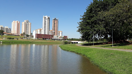
Indaiatuba on the map, Brazil
Where is located Indaiatuba
Exact location — Indaiatuba, Indaiatuba, São Paulo, Brazil, marked on the map with a red marker.
Coordinates
Indaiatuba, Brazil coordinates in decimal format: latitude — -23.0886774, longitude — -47.2089544. When converted to degrees, minutes, seconds Indaiatuba has the following coordinates: -23°5′19.24 north latitude and -47°12′32.24 east longitude.
Population
Indaiatuba, Indaiatuba, São Paulo, Brazil, according to our data the population is — 179,914 residents, which is about 0.1% of the total population of the country (Brazil).
Comparison of the population on the graph:
Exact time
Time zone for this location Indaiatuba — UTC -3 America/Sao_Paulo. Exact time — saturday, 4 april 2024 year, 08 h. 24 minutes.
Sunrise and sunset
Indaiatuba, sunrise and sunset data for a date — saturday 20.04.2024.
| Sunrise | Sunset | Day (duration) |
|---|---|---|
| 06:26 -0 minutes | 17:48 -1 minute | 11 h. 24 minutes. -1 minute |
You can control the scale of the map using the auxiliary tools to find out exactly where it is located Indaiatuba. When you change the scale of the map, the width of the ruler also changes (in kilometers and miles).
Nearby cities
The largest cities that are located nearby:
- Itu — 20 km
- Campinas — 25 km
- Hortolândia — 26 km
- Sumaré — 30 km
- Jundiaí — 33 km
- Americana — 41 km
- Várzea Paulista — 42 km
- Santa Bárbara D'Oeste — 42 km
- Francisco Morato — 52 km
- Sorocaba — 52 km
- Franco da Rocha — 55 km
- Jandira — 58 km
- Barueri — 58 km
- Itapevi — 58 km
- Piracicaba — 59 km
- Carapicuiba — 61 km
- Cotia — 64 km
- Osasco — 65 km
- Atibaia — 66 km
Distance to neighboring capitals:
- Asuncion
 (Paraguay) — 1079 km
 - Asuncion (Paraguay) — 1085 km
- Montevideo
 (Uruguay) — 1575 km
 - Buenos Aires
 (Argentina) — 1678 km
 - Nuestra Señora de La Paz
 (Bolivia) — 2308 km
 - Santiago
 (Chile) — 2560 km
 - Paramaribo
 (Suriname) — 3334 km
 - Georgetown
 (Guyana) — 3532 km
 - Quito
 (Ecuador) — 4231 km
 - Bogota
 (Colombia) — 4242 km
 - Caracas
 (Venezuela) — 4311 km