
 Bel-Ha
San Jose El Alto
El Porvenir
Nueva Palestina
Santa Lucía
Chemax
La Morita
Temoac
Zacualpan
Bel-Ha
San Jose El Alto
El Porvenir
Nueva Palestina
Santa Lucía
Chemax
La Morita
Temoac
Zacualpan
Puerta de Tierra on the map, Campeche, Mexico
Photo
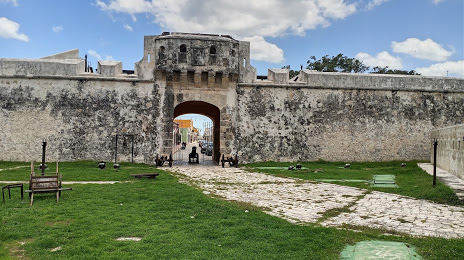
Where is located Puerta de Tierra
Puerta de Tierra — local attraction, which is located at Av Cto Baluartes, Zona Centro, 24000 Campeche, Camp., Mexico and belongs to the category — historical place. Average visitor rating for this place — 4.6 (according to 2632 ratings, information from open sources and relevant for 2022).
Exact location — Puerta de Tierra, marked on the map with a red marker.
You can get directions to Puerta de Tierra on the map from your location.
What else is interesting in Campeche? You can see all the sights if you go to the city page.
Coordinates
Puerta de Tierra, Mexico coordinates in decimal format: latitude — 19.836162740855496, longitude — -90.49406669285271. When converted to degrees, minutes, seconds Puerta de Tierra has the following coordinates: 19°50′10.19 north latitude and -90°29′38.64 east longitude.
Nearby cities
The largest cities that are located nearby:
- Merida — 159 km
- Ciudad del Carmen — 186 km
- Chetumal — 277 km
- Villahermosa — 325 km
- Cancún — 407 km
- San Cristóbal de las Casas — 408 km
- Tuxtla Gutiérrez — 436 km
- Coatzacoalcos — 453 km
- Minatitlán — 469 km
- Choloma
 (Honduras) — 543 km
 - San Pedro Sula (Honduras) — 548 km
- Quetzaltenango
 (Guatemala) — 562 km
 - San Juan Sacatepéquez (Guatemala) — 565 km
- El Progreso (Honduras) — 570 km
- Tapachula — 575 km
- Guatemala City (Guatemala) — 577 km
- Villa Nueva (Guatemala) — 586 km
- Villa Canales (Guatemala) — 592 km
- La Ceiba (Honduras) — 597 km
Distance to the capital
Distance to the capital (Mexico City) is about — 906 km.